

On the morning of April 18, 1906, San Francisco shook itself apart. Within a minute, streets buckled, brick buildings folded, and fires started that would burn for three days. People who survived described the ground moving like the deck of a ship in a storm. What nobody in the city knew that morning — what no scientist on Earth yet knew — was that the disaster had a cause far bigger than a single fault line. The city sat on the edge of two slabs of rock the size of continents, grinding past each other at about the speed your fingernails grow.
That slow, unstoppable grinding is the subject of this article. Plate tectonics is the theory that Earth's outer shell is broken into a dozen or so rigid plates that drift across the planet, carrying continents and ocean floors with them. Their movement builds the highest mountains on Earth, opens new oceans, and sets off almost every earthquake and volcanic eruption we experience. It is, quite simply, the engine that reshapes the surface of our planet — and it took most of the twentieth century for science to accept it.
I first felt the reality of this theory in a very unglamorous place: a university teaching lab, holding a chunk of basalt dredged from the Mid-Atlantic Ridge in one hand and a piece of granite from a continent in the other. The basalt was dark, heavy, and young — a few million years old at most. The granite was light, speckled, and ancient. Two rocks, two completely different histories, and the difference between them turned out to be the key to understanding why the ground beneath our feet never truly stands still.
1. What Plate Tectonics Actually Means
Strip away the jargon and plate tectonics makes one bold claim: the solid ground under your feet is not fixed. It moves. Slowly — centimetres per year — but relentlessly, and it has been moving for billions of years.
1.1 Earth's layered interior: the engine room
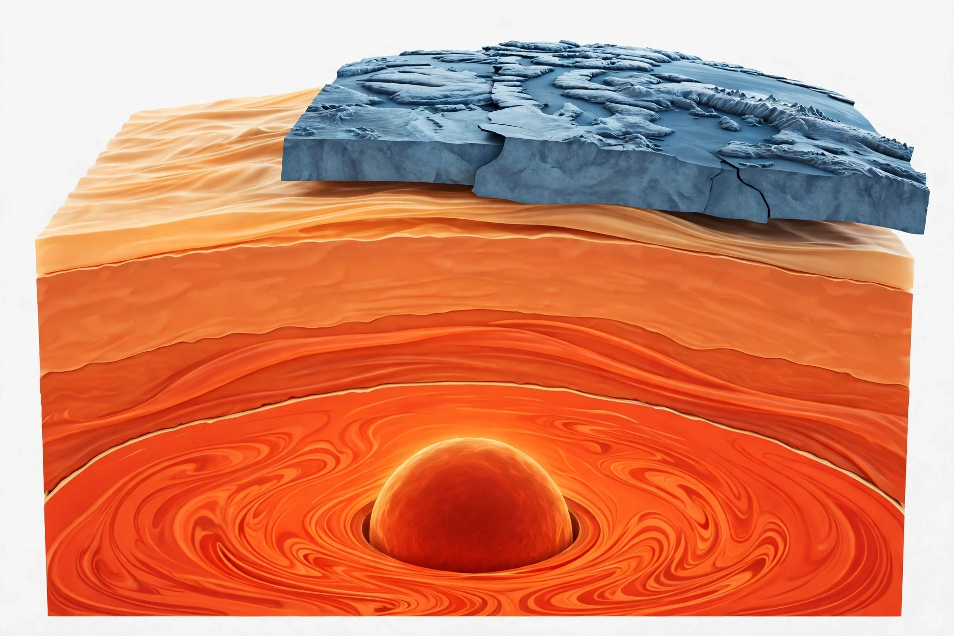
To understand why the ground moves, you have to look down. Earth is built in layers, and the behaviour of each layer decides what happens at the surface.
At the centre sits the inner core, a ball of solid iron and nickel about the size of the Moon, heated to roughly 5,200°C — about as hot as the surface of the Sun — and squeezed solid by the weight of everything above it. Around it lies the outer core, liquid iron and nickel whose churning generates Earth's magnetic field. Above that is the mantle, a 2,900-kilometre-thick layer of hot rock that makes up about 84 percent of Earth's volume. And on top, a thin skin: the crust, 5 to 10 kilometres thick under the oceans and 35 to 70 kilometres thick under the continents.
Here is the part that trips most people up, and it tripped me up too when I first studied it. The tectonic plates are not the crust. A plate is the lithosphere — the crust plus the rigid top slice of the mantle, fused into a single stiff slab roughly 100 kilometres thick. Below the lithosphere sits the asthenosphere, a layer of mantle rock so hot and under so much pressure that it can creep and flow over geological time, the way a block of cold honey slowly sags if you leave it on a shelf. The plates slide across the asthenosphere the way a raft slides across a slow river.
1.2 The plates themselves
Earth's lithosphere is fractured into about seven or eight major plates and dozens of smaller ones. The big names are worth knowing because they appear in every earthquake and volcano story you will ever read: the Pacific, North American, South American, Eurasian, African, Indo-Australian, and Antarctic plates.
Each plate carries whatever sits on top of it — continents, ocean floor, or a mix of both. That is a crucial point. Continents do not plough through the ocean floor like ships through water, the way early theorists imagined. They ride passively on plates, the way a passenger rides on a train. When a plate moves, everything on it moves too.
Plates move at speeds of roughly 1 to 15 centimetres per year, according to the U.S. Geological Survey — about as fast as your fingernails grow, and in the fastest cases about as fast as your hair grows. That sounds trivial until you multiply it by deep time. At 2.5 centimetres a year, the Atlantic Ocean has widened by 25 kilometres in a million years, and by thousands of kilometres since it began opening around 200 million years ago. Slow motion, given enough time, rearranges the world.
2. The Idea Nobody Believed: Wegener and Continental Drift
Every great theory starts with someone noticing something odd and refusing to let it go. For plate tectonics, that someone was Alfred Wegener, a German meteorologist and polar explorer who, in December 1910, wrote to his future wife about a map he could not stop staring at.
2.1 The puzzle-piece clue
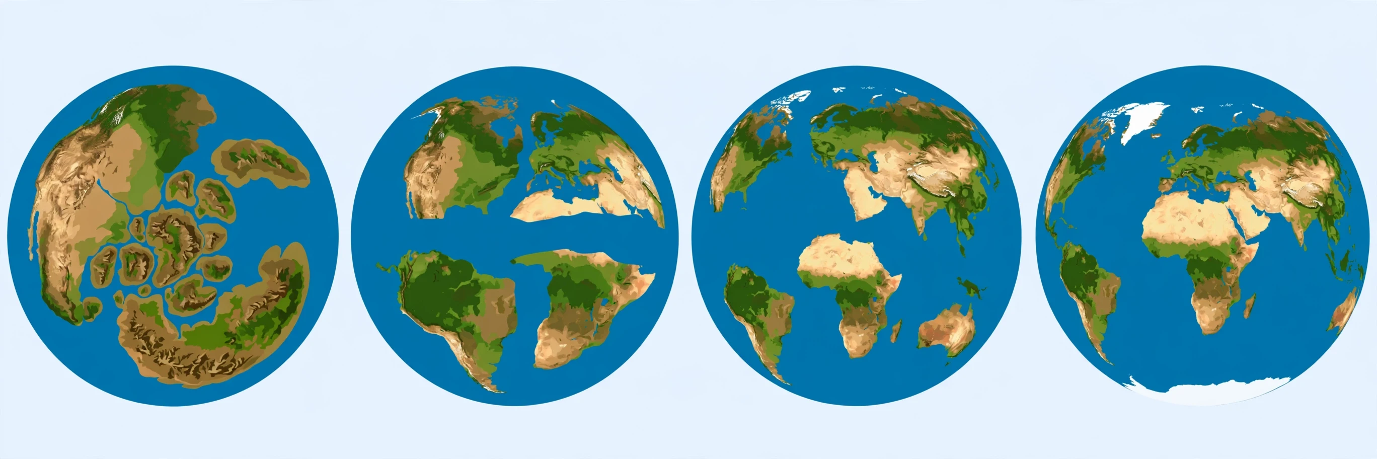
"Doesn't the east coast of South America fit exactly against the west coast of Africa, as if they had once been joined?" Wegener wrote. He was right — the fit is uncanny. But he did not stop at coastlines. Over the next few years he gathered evidence from completely different fields: identical fossil animals and plants found on continents now separated by thousands of kilometres of ocean; matching mountain ranges and coal deposits that continue seamlessly from Africa into South America; and traces of ancient glaciers in places that are now tropical desert, alongside tropical fossils in Antarctica.
On January 6, 1912, Wegener presented his theory of continental drift to the Geological Association in Frankfurt. His claim was simple and radical: about 300 million years ago, all the continents had been joined in a single supercontinent he called Pangaea — "all lands" — and it had broken apart about 200 million years ago, with the pieces drifting to their present positions. He published the full case in his 1915 book, The Origin of Continents and Oceans.
2.2 Why the experts said no
And then the scientific establishment tore him apart. The president of the American Philosophical Society called the idea "utter, damned rot." A British geologist said anyone who valued their reputation for scientific sanity would never support such a theory. At a 1926 symposium in New York called to discuss his work, speaker after speaker mocked him. Wegener sat smoking his pipe and listened.
The critics had a fair objection, and honesty demands we admit it. Wegener could not explain what force could move whole continents. He suggested the Earth's rotation and the Moon's gravity might do it, but the numbers did not work — the forces he proposed were far too weak. He also pictured continents ploughing through solid oceanic crust, which physicists showed was mechanically impossible. As the NASA Earth Observatory account of his life puts it, his major problem was finding a force that could make the continents "plow around in the mantle."
Wegener died in Greenland in 1930, on an expedition to study the ice cap, still defending a theory most geologists considered a fairy tale. He never lived to see himself proved right. I think about that whenever I catch myself dismissing an idea because it does not yet have a mechanism attached. Wegener's evidence was excellent; his mechanism was wrong. The evidence deserved better than the ridicule it got.
3. The Ocean Floor Gives Up Its Secret: Seafloor Spreading
The vindication of Wegener's idea came from a place he never studied: the bottom of the ocean. And it arrived, fittingly, through war.
3.1 Hess and the wartime maps
Harry Hess was a Princeton geologist who served in the U.S. Navy during the Second World War, commanding a transport ship in the Pacific. Between duties, he kept the ship's echo sounder running and mapped the ocean floor as he sailed. What he found was astonishing: the ocean floor was not the flat, featureless plain everyone assumed. It was rugged — cut by a vast underwater mountain chain running down the middle of every ocean basin, and scarred by deep trenches near the continents.
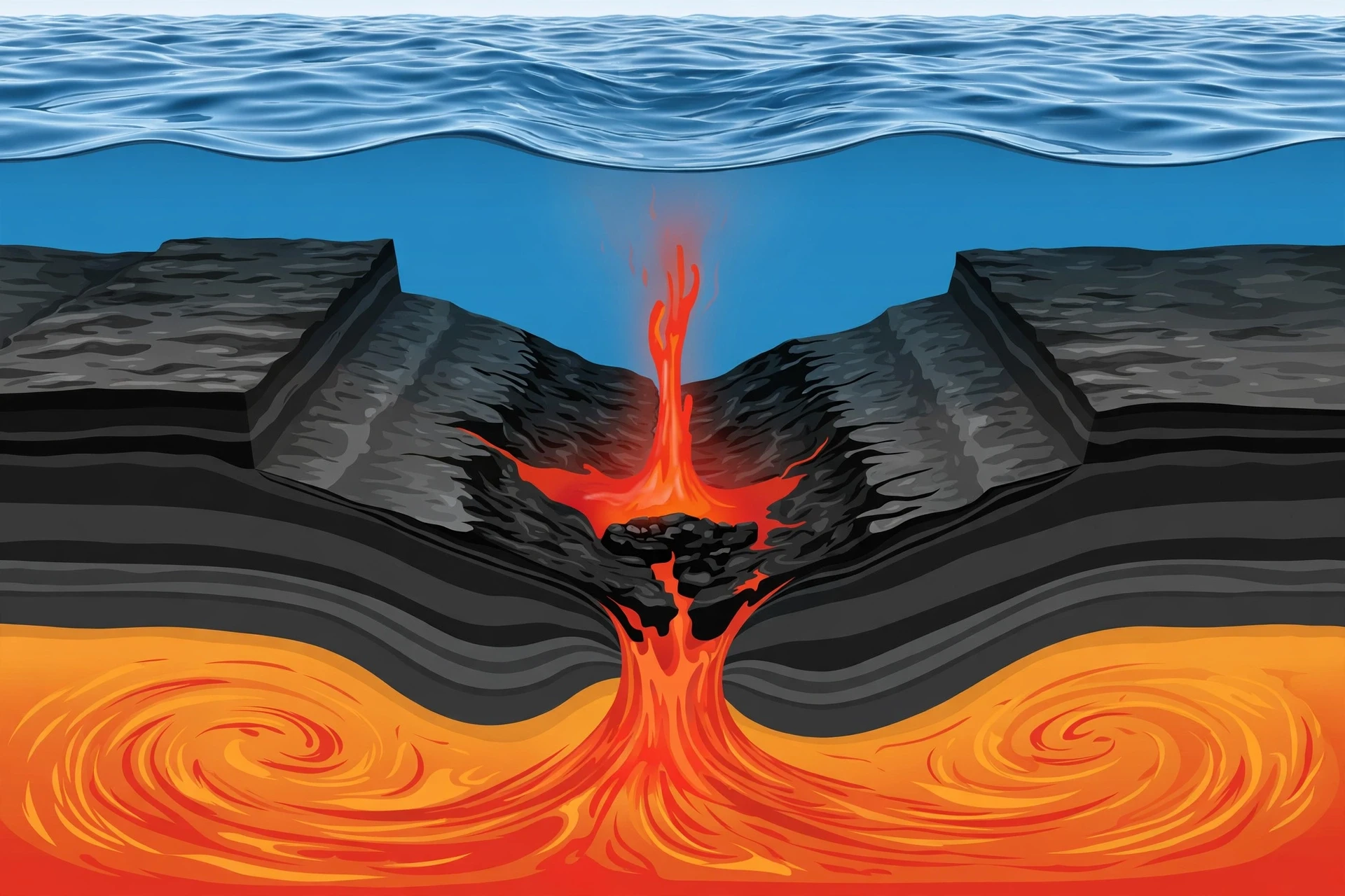
After the war, Hess put the pieces together. In a 1962 paper he proposed seafloor spreading: hot mantle rock rises at mid-ocean ridges, cools into new oceanic crust, and the two sides of the ridge are pushed apart like two conveyor belts moving in opposite directions. The ocean floor, he realised, is constantly being created at ridges and destroyed somewhere else. Continents do not plough through the sea floor at all — they are carried along on plates that are created at ridges and consumed at trenches.
There is a detail I love about this story. Hess first circulated his idea in 1960 as an unpublished preprint, and he titled it, with unusual modesty for a scientist, "An Essay in Geopoetry." He knew he was guessing at parts of it. Within a few years, the guessing was over.
3.2 Magnetic stripes: the tape recorder in the rock
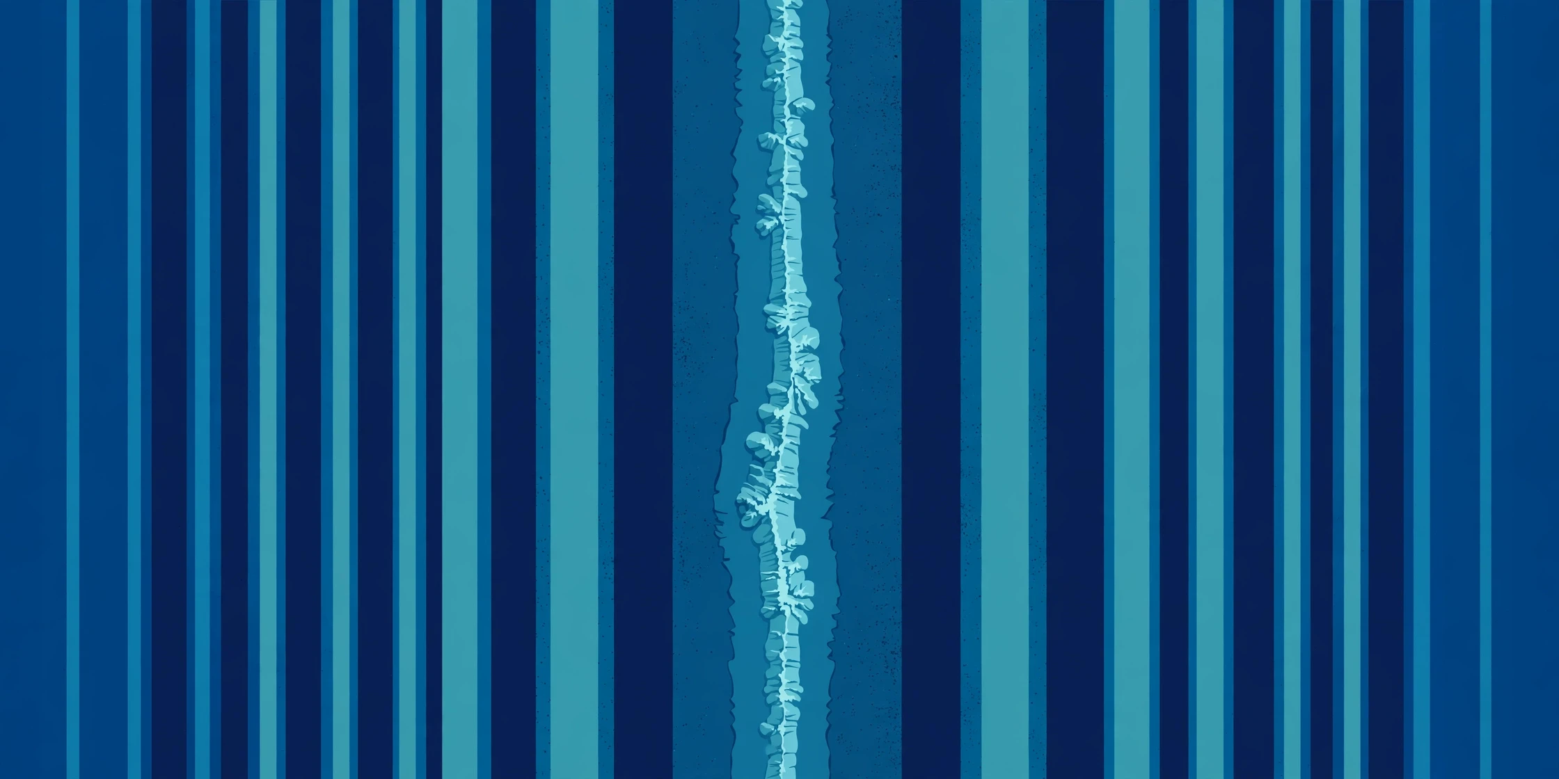
The proof came from magnetism. As new crust forms at a mid-ocean ridge, iron-rich minerals in the cooling lava align themselves with Earth's magnetic field, like tiny compass needles freezing in place. Earth's magnetic field reverses direction every few hundred thousand years or so — north becomes south and back again — and each reversal is recorded in the newly formed rock.
In 1963, Fred Vine and Drummond Matthews (working independently of Lawrence Morley, who had the same idea but could not get it published) predicted what this should look like: the ocean floor should carry a pattern of magnetic "stripes" — bands of normal and reversed polarity running parallel to the ridge, mirrored symmetrically on either side, like a barcode. When survey ships mapped the magnetism of the sea floor, the stripes were exactly there. The ocean floor was a tape recorder, and it had recorded its own spreading.
That discovery converted the sceptics in a matter of years. By 1968, seafloor spreading and continental drift had fused into a single theory — plate tectonics — and geology has never looked back.
4. What Moves the Plates?
This is the question Wegener could not answer, and the honest answer is that science still debates the details. But the broad picture is now clear, and it is more interesting than the simple "conveyor belt" picture many textbooks still print.
4.1 Mantle convection: the heat engine
Earth's interior is hot, and heat has to escape. Deep in the mantle, hot rock slowly rises, cools near the surface, and sinks again — a churning circulation called mantle convection. Think of a pot of thick soup on a low burner: the broth rises in the hot middle, spreads out at the top, cools at the edges, and sinks back down. The mantle does the same thing, except the "soup" is solid rock creeping a few centimetres a year, and one circuit takes tens of millions of years.
For decades, convection was taught as the main driver of plate motion — the mantle dragging the plates along like a conveyor belt. Modern research has complicated that picture. Seismic imaging has not found the giant, simple convection cells the textbook model predicts, and geologists now think the plates themselves do much of the driving.
4.2 Slab pull and ridge push: the plates drive themselves
Two forces now take centre stage. Slab pull is the heavyweight. As oceanic crust ages and moves away from its ridge, it cools, thickens, and grows denser than the asthenosphere beneath it. When it finally reaches a subduction zone, its own weight drags it down into the mantle — and the sinking edge hauls the rest of the plate along behind it, like a tablecloth sliding off a table and pulling the dishes with it. Evidence suggests slab pull is the dominant force moving plates.
Ridge push is the smaller partner. New crust formed at a mid-ocean ridge sits high and hot, and as it cools it slides gently downhill away from the ridge crest, pushing the plate outward. It is real, but weaker than slab pull.
There is also basal drag — friction between the moving plate and the mantle beneath — though researchers argue about whether it helps or resists motion. The modern view, as the Geological Society and others describe it, is a coupled system: sinking slabs help drive mantle circulation, rather than the mantle simply dragging passive plates around. The plates are not cargo on a conveyor belt. They are part of the engine.
"The forces which displace continents are the same as those which produce great fold-mountain ranges. Continental drift, faults and compressions, earthquakes, volcanicity... are undoubtedly connected on a grand scale." — Alfred Wegener, 1929
Wegener wrote that decades before anyone could prove it. He was right about the connection. He was just early.
5. The Three Plate Boundaries
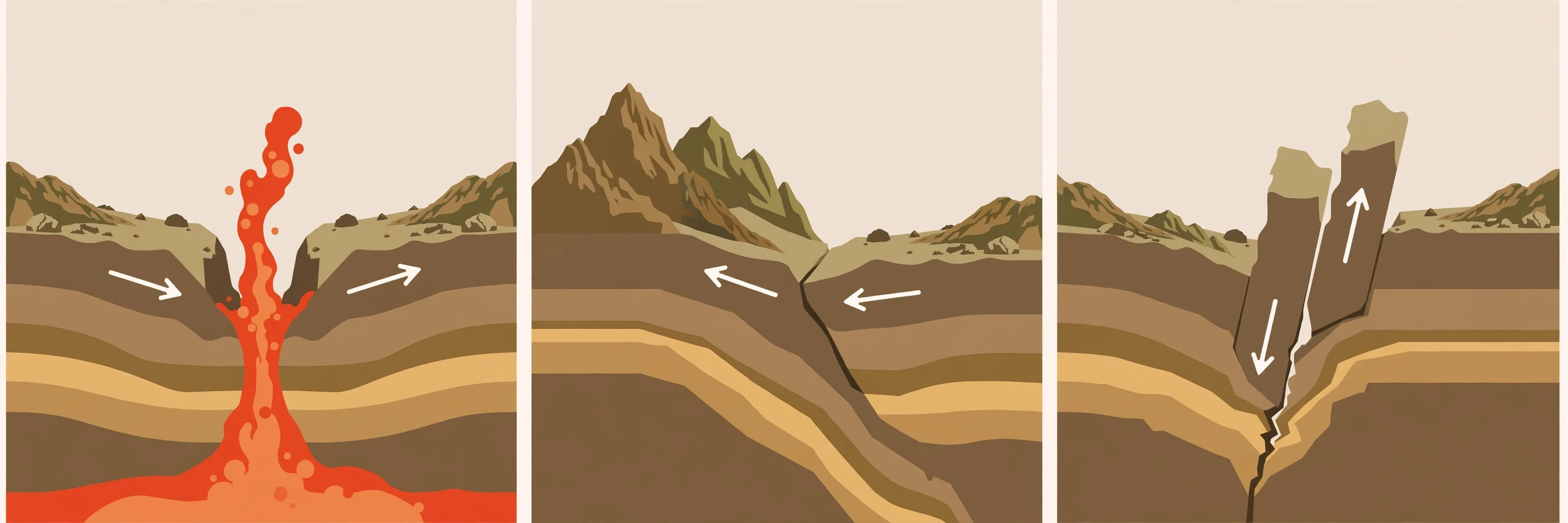
Plates are rigid in their interiors, so almost all the action happens at their edges — the plate boundaries. Every boundary falls into one of three types, defined by how the plates move relative to each other. Learn these three, and you can explain most of the dramatic geology on Earth.
Boundary type | Plate motion | What happens | Classic examples |
|---|---|---|---|
Divergent | Plates move apart | New crust forms; rift valleys and mid-ocean ridges | Mid-Atlantic Ridge; East African Rift |
Convergent | Plates move together | Crust is destroyed; trenches, mountains, volcanoes | Himalayas; Andes; Mariana Trench |
Transform | Plates slide past each other | Crust is neither created nor destroyed; faults and earthquakes | San Andreas Fault; Alpine Fault, New Zealand |
5.1 Divergent boundaries: where new crust is born
At a divergent boundary, two plates pull away from each other and magma rises from below to fill the gap, cooling into fresh oceanic crust. Under the oceans, this builds the mid-ocean ridge system — a 65,000-kilometre chain of underwater mountains that wraps around the planet like the seams on a baseball, and the longest mountain range on Earth.
The Mid-Atlantic Ridge is the best-known example. It spreads at about 2.5 centimetres a year, and over the past 100 to 200 million years it has grown the Atlantic from a narrow inlet into a vast ocean — a rate and history documented in the U.S. Geological Survey's This Dynamic Earth. Iceland is the one place where a mid-ocean ridge rises above sea level, and you can walk between the North American and Eurasian plates there — in places, the ground is visibly splitting, with cracks widening a few centimetres a year.
Divergent boundaries also tear continents apart. In East Africa, the African Plate is splitting into the Nubian and Somalian plates along the East African Rift. The Red Sea formed the same way, when Arabia tore away from Africa. NASA's Earth Observatory notes that the Afar Depression, where three plates meet, is the birthing ground for a new ocean: in a few million years, the Indian Ocean may flood in and turn the Horn of Africa into a large island. Geologists get to watch an ocean being born, on dry land, in real time.
5.2 Convergent boundaries: where crust is destroyed
At a convergent boundary, two plates collide, and something has to give. What gives depends on what kind of crust is involved.
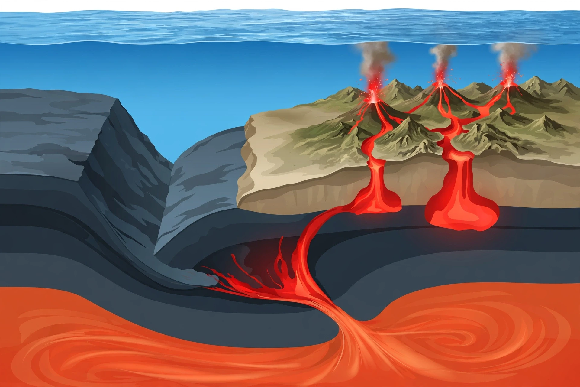
When an oceanic plate meets a continental plate, the dense oceanic plate dives beneath the lighter continental plate in a process called subduction. The sinking plate bends down into the mantle along a deep ocean trench — trenches are the deepest places on Earth's surface, 8 to 10 kilometres down. Off South America, the Nazca Plate is subducting beneath the South American Plate along the Peru-Chile Trench, lifting the Andes and feeding its volcanoes. Off Japan, the Pacific Plate dives beneath the islands, and the Mariana Trench marks where the fastest-moving plate on Earth meets the slower Philippine Plate; the Challenger Deep, at nearly 11,000 metres, is deeper than Mount Everest is tall.
When two oceanic plates converge, one still subducts, and the volcanoes that grow above the sinking slab eventually rise out of the sea as island arcs — curving chains like Japan, the Aleutians, and the Marianas.
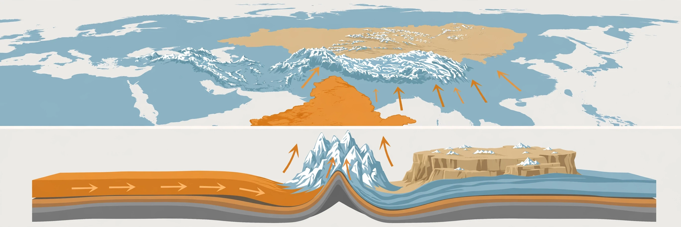
When two continental plates collide, neither can subduct, because continental crust is too light and buoyant — it floats like a cork. Instead, the crust crumples, folds, and thickens, piling up into great mountain ranges. The Himalayas are the textbook case, and they get a section of their own below.
5.3 Transform boundaries: where plates grind past
At a transform boundary, plates slide horizontally past each other. No crust is created and none is destroyed — but the friction is enormous. The plates stick, strain builds up over years or decades, and then they lurch past each other in an earthquake.
The San Andreas Fault in California is the most famous transform boundary on land. It runs about 1,300 kilometres through two-thirds of the state, connecting two spreading ridges, and the Pacific Plate has been grinding past the North American Plate along it for about 10 million years at roughly 5 centimetres a year. Land west of the fault is moving northwest relative to land east of it — Los Angeles and San Francisco are, very slowly, sliding toward each other. They will meet in about 20 million years, which is either reassuring or alarming depending on your sense of time.
Most transform faults are on the ocean floor, where they offset spreading ridges in a zig-zag pattern. The few on land — San Andreas, New Zealand's Alpine Fault, Turkey's North Anatolian Fault — are among the most earthquake-prone places on Earth.
6. How Plate Movement Builds Mountains
Mountains are not just scenery. They are the visible wreckage of plate collisions — and the Himalayas are the greatest pile-up on the planet.
About 50 million years ago, the Indian Plate, then an island continent drifting north across the ancient Tethys Ocean, slammed into the Eurasian Plate. Because both plates carried light continental crust, neither could subduct. Instead, the crust buckled and doubled up, pushing the Himalayas and the Tibetan Plateau skyward. The collision is still going on: India keeps pushing north at about 5 centimetres a year, and the Himalayas keep rising by roughly 5 millimetres a year — a rate that sounds small until you remember it has been going on for 50 million years.
The result is the highest ground on Earth. Mount Everest stands 8,854 metres above sea level, and the Tibetan Plateau averages about 4,600 metres — higher than every peak in the Alps except Mont Blanc. Here is a detail I still find startling: the summit of Everest is made of marine limestone, laid down on an ancient sea floor. You can find fossil seashells near the top of the world, because the top of the world used to be the bottom of an ocean.
Subduction builds mountains too, differently. Above a subduction zone, magma generated from the sinking slab rises and solidifies underground, and volcanic eruptions pile up layer upon layer. The Andes — the longest continental mountain range on Earth — rose this way, as the Nazca Plate slid beneath South America. The Sierra Nevada in California has a similar origin: a vast body of cooled magma, exposed by erosion, forming the core of the range.
And mountains have afterlives. The Appalachians, running down the eastern United States, are the eroded stumps of a collision as violent as the Himalayan one — the crash that assembled Pangaea hundreds of millions of years ago. They were once as tall as the Himalayas. Time and weather have worn them down to rounded ridges. Mountains rise on plate boundaries, and when the plates move on, erosion takes them apart again.
7. How Plate Movement Causes Earthquakes
Here is the most common misunderstanding I run into when I talk about this subject: people imagine earthquakes as something that happens to the Earth, like weather. They are better understood as something the Earth does — the sound of plates moving.
At plate boundaries, the edges of plates are not smooth. They are rough, jagged, and locked together by friction. The plates keep trying to move, driven by slab pull and ridge push, but the locked boundary holds. Strain builds up in the rock, year after year, like a bent branch. Eventually the stress exceeds the strength of the rock, the boundary breaks, and the plates lurch forward — sometimes by metres in a few seconds. That sudden release of stored energy is an earthquake.
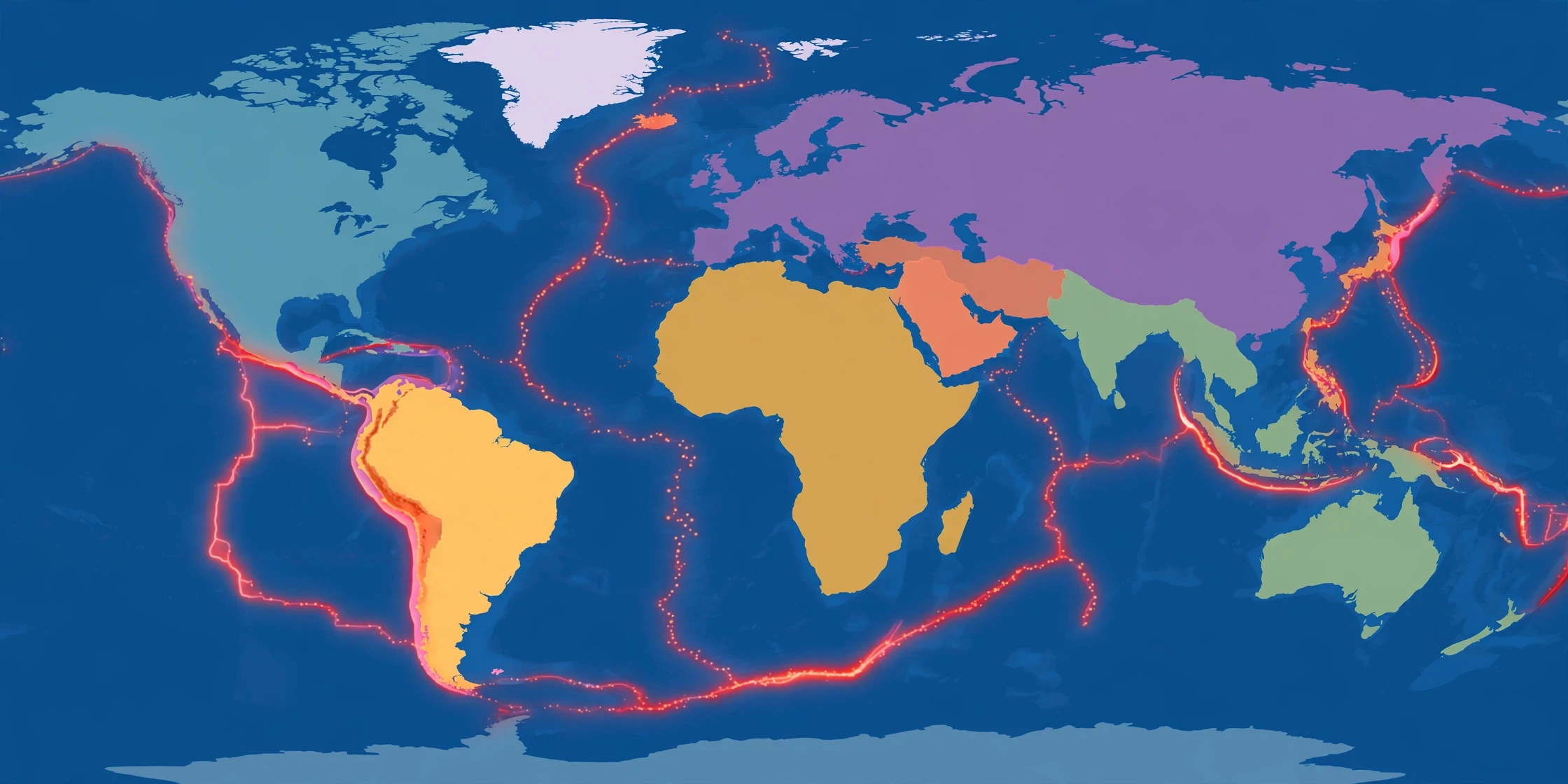
This is why earthquakes cluster where they do. More than 80 percent of the world's earthquakes occur along or near plate boundaries, according to the U.S. Geological Survey. Subduction zones produce the largest earthquakes on record, because the contact between the plates is enormous and the locked zone can rupture over hundreds of kilometres at once. The 2004 Sumatra earthquake and the 2011 Tohoku earthquake in Japan were both megathrust ruptures at subduction zones. Transform boundaries like the San Andreas produce strong, shallow earthquakes. Divergent boundaries produce earthquakes too, but they tend to be smaller, because the plates are pulling apart rather than locking and building up huge strain.
There is an important nuance here. The ground does not have to be at a boundary to shake — strain can travel deep into a plate's interior, which is why places far from any boundary occasionally get earthquakes. But the pattern is overwhelming: draw a map of the world's earthquakes, and you have drawn a map of the plate boundaries.
I am deliberately keeping the earthquake mechanics brief here, because Sciory already has a full guide to the subject. For how seismic waves travel, how earthquakes are measured, and what the magnitude scales actually mean, read our companion article, Earthquakes Explained: Causes, Seismic Waves, and Measurement. What matters for this article is the cause: without moving plates, there would be almost no earthquakes at all.
8. How Plate Movement Causes Volcanoes
Volcanoes follow the same map as earthquakes, for the same reason. Most of the world's volcanoes sit on plate boundaries, and the boundary type decides what kind of volcano you get.
At divergent boundaries, magma rises to fill the gap between separating plates. Under the oceans, this builds the volcanic ridges themselves. On land, it produces rift volcanoes like Erta Ale in Ethiopia and the shield volcanoes of Iceland, where eruptions tend to be fluid and runny, with lava flowing rather than exploding.
At subduction zones, volcanoes form for a subtler reason. The sinking plate carries seawater and minerals down with it. As it descends and heats up, water is squeezed out of the slab — and water lowers the melting point of the hot mantle rock above it, the way salt lowers the melting point of ice. The mantle melts, the magma rises, and a chain of volcanoes forms on the overriding plate, roughly 100 kilometres above the sinking slab. This is how the Cascade Range formed in the Pacific Northwest, the Andes in South America, and the island arcs of Japan and Indonesia. These volcanoes tend to be explosive, because their magma is rich in water and silica — a combination that traps gas until it bursts out.
Then there are the exceptions that prove the rule: hotspots. Hawaii sits in the middle of the Pacific Plate, thousands of kilometres from any boundary, yet it hosts some of the world's most active volcanoes. The explanation is a plume of hot mantle rock rising from deep below, burning a hole through the plate as the plate drifts over it — like a sheet of paper sliding over a candle flame. The result is a chain of islands and seamounts: the older islands to the northwest, the younger ones to the southeast, recording the plate's motion like footprints. Hotspots are a reminder that the theory still has open questions — researchers still debate how deep mantle plumes really start — but they fit neatly into the plate framework: the islands move because the plate moves.
For the full story of volcano types, eruption styles, and famous eruptions, see our companion guide, How Volcanoes Form, Types, and Eruptions Explained.
9. The Evidence All Around Us
Plate tectonics is not a theory you have to take on trust. Its evidence is visible from the ground, from the sea floor, and now from space.
Matching fossils and rocks. Identical species of ancient freshwater reptiles and seed ferns appear on continents now separated by oceans. The simplest explanation is that the continents were once joined — and every alternative requires inventing sunken land bridges that physics says could not exist.
The age of the ocean floor. The oldest sea floor on Earth is only about 180 million years old, while continental rocks date back 4.3 billion years. The ocean floor is young everywhere because it is constantly being made and recycled. If the sea floor were as old as the continents, the ocean basins would be buried under kilometres of sediment. They are not.
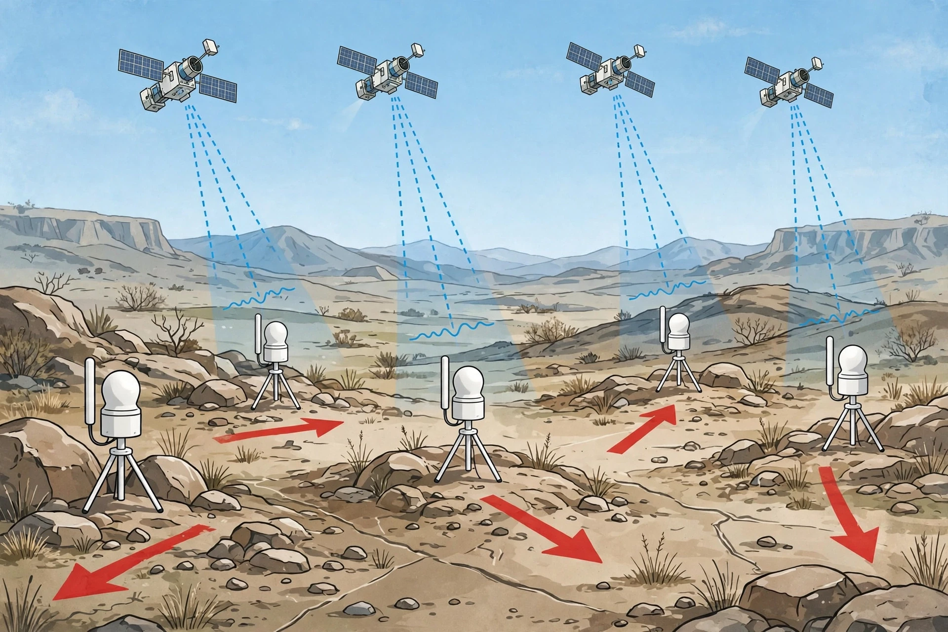
GPS measurements. Today, satellites measure plate motion directly. GPS stations around the world record their positions shifting by millimetres each year — the same rates predicted by the magnetic stripes and the fossil record. We can now watch continents move in real time, and the Pacific Northwest Seismic Network reports GPS velocities of up to 11 centimetres a year in parts of the western United States. When I first saw a plot of GPS arrows sweeping across a map of North America, each arrow pointing in the direction its patch of ground was actually travelling, the abstraction of plate tectonics became something I could see.
Earthquake and volcano maps. Plot every earthquake and volcano on a world map and the plate boundaries draw themselves. The pattern is too sharp and too consistent to be coincidence.
The fit of the continents. It is not just South America and Africa. Reassemble the continents into Pangaea and the geological features line up: mountain ranges continue across the join, coal beds match, and ancient glacial deposits cluster neatly around the South Pole — exactly where they would have been if the southern continents were once one landmass.
One more piece of evidence is personal and recent. In the Afar region of Ethiopia, the ground is splitting apart in real time along the East African Rift, and satellite radar has measured sudden rifting events in which the crust tore open by metres in a matter of days. The Atlantic Ocean began the same way, about 200 million years ago. Afar is a live demonstration that the processes in this article are not history — they are happening now.
10. Common Misconceptions About Plate Tectonics
Most people carry a few wrong ideas about how the Earth works. Here are the ones I hear most often — and what the data actually shows.
"The continents float on liquid magma." Most people assume the mantle is a sea of molten rock with continents bobbing on it like icebergs. What we actually see in the data is different: the mantle is solid rock. It is hot enough to creep and flow over millions of years, but it is not liquid. The asthenosphere behaves like solid rock that is soft enough to deform — closer to warm glass or cold honey than to water. The "floating" image is a useful shorthand, but taken literally it is wrong.
"Earthquakes happen because the Earth is cracking apart." Earthquakes do involve rock breaking, but the deeper cause is plates moving and getting stuck. The crack is the release, not the cause. The cause is motion — slow, steady, and unstoppable.
"Pangaea was the first supercontinent." Pangaea was the most recent one, not the first. Several earlier supercontinents assembled and broke apart before it, though the evidence gets harder to read the further back you go. The cycle of supercontinents forming and splitting apart is one of the longest rhythms in Earth's history, and some researchers expect a new one — sometimes called Pangaea Ultima or Amasia — to form hundreds of millions of years from now.
"Plate tectonics explains everything about Earth's surface." It explains a great deal, but not everything. The theory describes the outer shell; it does not fully explain the deep mantle, the origin of the plates themselves, or exactly how the first plates formed billions of years ago. Researchers still argue about how much of plate motion comes from slab pull versus mantle convection, and about whether plate tectonics operated the same way in Earth's first billion years. A good theory admits its edges.
"The plates move because the Earth is cooling and shrinking." This was the dominant idea before plate tectonics, and Wegener spent much of his career arguing against it. A shrinking Earth would produce wrinkles spread evenly across the surface, like a drying apple. What we observe instead is deformation concentrated in narrow bands — the plate boundaries. The cooling-Earth model cannot explain that pattern. Plate tectonics can.
11. What Plate Tectonics Means for Us
Plate tectonics is not only a story about the deep past. It shapes where we live, what we build, and how we prepare for disaster.
Hazard maps and building codes. Because earthquakes and volcanoes follow plate boundaries, geologists can map where the danger is greatest and how strong the shaking is likely to be. Building codes in California, Japan, Chile, and Indonesia are written around plate-boundary science. The 2011 Tohoku earthquake was a tragedy, but the fact that Japan's buildings and warning systems performed as well as they did is a direct product of understanding subduction zones.
Finding resources. The same processes that build mountains concentrate minerals. Copper, gold, and other metals are deposited by hot fluids circulating near plate boundaries, which is why Chile — sitting above the subduction zone where the Nazca Plate dives under South America — produces roughly a quarter of the world's mined copper. Oil and gas collect in basins formed by rifting and plate movement. Geologists prospect with plate maps in hand.
Geothermal energy. Where plates pull apart or magma sits close to the surface, Earth's heat is within reach. Iceland generates much of its electricity and heating from geothermal energy tapped along the Mid-Atlantic Ridge. The same heat that drives plate motion can heat homes.
Understanding the oceans and climate. Plate movement rearranges ocean basins, which changes ocean currents, which changes climate. The closing of the ancient seaway between North and South America, as the Panama land bridge formed a few million years ago, redirected ocean circulation and helped set the stage for the ice ages. To understand Earth's climate history — and to model its future — you need to know where the continents were. That is why the same plate reconstructions that explain fossils also appear in climate models. If you want the ocean side of the story, our guide to Oceanography: Currents, Ecosystems, and Depth Zones picks up where this article leaves off — and for the weather and climate systems that ride on top of those currents, see Meteorology Explained: Weather and Forecasting.
Latest research. The field has not stood still since 1968. Satellite geodesy now tracks plate motion to the millimetre, and recent studies of the East African Rift are measuring how quickly a new ocean basin opens. Researchers using seismic imaging have mapped subducted slabs sinking deep into the mantle — some all the way to the core-mantle boundary — and are debating whether those slabs stir the deep mantle or pile up there. In 2023 and 2024, new GPS and seismic studies of the Afar region sharpened estimates of how rifting events unfold in days rather than millennia. And the open question Wegener could not answer — what exactly drives the plates — is still being refined: the current consensus is a coupled system in which slab pull leads and mantle convection assists, but the balance is still being measured, not assumed.
The Ground Beneath Us Is Moving
The ground under your feet feels permanent. It is not. It is drifting at the speed your fingernails grow, carrying continents, opening oceans, raising mountains, and occasionally — when the strain becomes too much — shaking cities apart. The same slow motion that built the Himalayas is, right now, widening the Atlantic, splitting Africa, and pushing Los Angeles toward San Francisco.
Wegener saw it first and was mocked for it. Hess found it on the ocean floor and called his own idea geopoetry. Vine and Matthews read it in magnetic stripes, and within a decade the most ridiculed idea in geology had become its foundation. That arc — from heresy to textbook — is worth remembering the next time an idea sounds impossible. The evidence was there all along, written in matching fossils, in the age of the sea floor, in the stripes of magnetised rock. It took a century to learn how to read it.
The next time you feel the ground tremble, or watch a volcano erupt on the news, or stand on a mountain and wonder how rock got so high — you are watching plate tectonics at work. The planet is still moving. It always has been.
Frequently Asked Questions
What is plate tectonics in simple terms?
Plate tectonics is the theory that Earth's outer shell is broken into large, rigid slabs called tectonic plates that slowly move over the hot, soft rock of the mantle below. Their movement carries continents, opens and closes oceans, builds mountains, and causes earthquakes and volcanoes. Plates move a few centimetres per year — about as fast as your fingernails grow.
How many tectonic plates are there?
There are seven or eight major plates — the Pacific, North American, South American, Eurasian, African, Indo-Australian, and Antarctic plates — plus dozens of minor plates, such as the Nazca, Cocos, Caribbean, and Arabian plates. The exact count depends on how geologists draw the boundaries, because some plates are split into smaller blocks.
How fast do tectonic plates move?
Plates typically move between 1 and 15 centimetres per year, according to the U.S. Geological Survey. The Mid-Atlantic Ridge spreads at about 2.5 centimetres a year, while the Pacific Plate moves at up to 11 centimetres a year in places. GPS satellites now measure these motions directly, millimetre by millimetre.
What causes tectonic plates to move?
The main driver is thought to be slab pull: dense, cold oceanic crust sinking into the mantle at subduction zones drags the rest of the plate behind it. Ridge push — new, high crust sliding away from mid-ocean ridges — adds a smaller push, and mantle convection, the slow churning of hot rock deep inside Earth, contributes as well. Researchers still debate the exact balance between these forces.
What are the three types of plate boundaries?
Divergent boundaries pull apart and create new crust (mid-ocean ridges, rift valleys). Convergent boundaries collide, destroying crust through subduction or building mountains (the Himalayas, the Andes, deep ocean trenches). Transform boundaries slide past each other, producing faults and earthquakes (the San Andreas Fault).
Why do earthquakes happen at plate boundaries?
At plate boundaries, the rough edges of plates lock together by friction while the plates keep trying to move. Strain builds up over years or decades until the rock breaks and the plates lurch forward, releasing the stored energy as an earthquake. More than 80 percent of earthquakes occur along or near plate boundaries. For the full guide to seismic waves and measurement, see Earthquakes Explained.
Why do volcanoes form at plate boundaries?
At divergent boundaries, magma rises to fill the gap between separating plates. At subduction zones, water carried down with the sinking plate lowers the melting point of the mantle above it, generating magma that rises to form volcanoes. This is why the Ring of Fire around the Pacific hosts most of the world's active volcanoes. For volcano types and eruption styles, see How Volcanoes Form, Types, and Eruptions Explained.
How were the Himalayas formed?
The Himalayas formed when the Indian Plate collided with the Eurasian Plate about 50 million years ago. Because both plates carry light continental crust, neither could subduct, so the crust crumpled and thickened, pushing the mountains upward. The collision is still happening, and the Himalayas are still rising by about 5 millimetres a year.
What is seafloor spreading?
Seafloor spreading is the process by which new oceanic crust forms at mid-ocean ridges: magma rises from the mantle, cools into new crust, and the plates on either side move apart. The oldest ocean floor on Earth is only about 180 million years old, because older crust has been recycled back into the mantle at subduction zones.
Will the continents keep moving?
Yes. The Atlantic Ocean is still widening, Africa is slowly splitting along the East African Rift, and India is still pushing into Asia. Over hundreds of millions of years, the continents are expected to reassemble into a new supercontinent, sometimes called Pangaea Ultima or Amasia. The map of the world is a snapshot, not a finished picture.
Sources
U.S. Geological Survey, This Dynamic Earth: The Story of Plate Tectonics — "Understanding Plate Motions." pubs.usgs.gov/gip/dynamic/understanding.html
U.S. Geological Survey, Volcano Hazards Program — "Plate Tectonics in a Nutshell." volcanoes.usgs.gov/about/edu/dynamicplanet/nutshell.php
NASA Earth Observatory — "Alfred Wegener: The Father of Continental Drift." earthobservatory.nasa.gov/features/Wegener/wegener_7.php
Pacific Northwest Seismic Network (University of Washington) — "Plate Tectonics." pnsn.org/education/seismology/plate-tectonics
University of Hawai'i, Exploring Our Fluid Earth — "Continental Movement by Plate Tectonics." manoa.hawaii.edu/exploringourfluidearth/physical/ocean-floor/continental-movement-plate-tectonics