

The siren started while I was standing in a wheat field in Oklahoma, on an afternoon when tornadoes were forecast across the Plains, watching a cloud that did not look like any cloud I had ever seen. It was late afternoon, the air was thick and warm enough to feel on your skin like a damp towel, and the sky to the west had gone the colour of old bruises — green at the edges, black in the middle. The cloud base hung low and flat, and underneath it, a smaller cloud was turning. Not drifting. Turning, slowly and deliberately, the way water turns above a drain. A farmer I had met that morning stood beside me with his hands in his pockets, watching the same sky, and he said, very calmly, "That one means business." Then the siren wound up in the distance, and we both walked — not ran, walked, because he had done this before — to his truck.
Nothing touched down that day, at least not where we were. The storm slid east, dropped heavy rain and hail the size of marbles, and the rotating cloud thinned out and fell apart. I remember feeling two things at once: relief, and a strange disappointment. I had travelled a long way to see a tornado, and the sky had shown me everything except the tornado itself. It took me years of reading, of standing in more fields, of talking to forecasters and to people who had lost roofs and barns and, in the worst cases, people they loved, to understand that what I felt that afternoon was the wrong way round. A tornado is not the show. It is the last, smallest part of a much larger machine — a machine built from heat, moisture, wind, and a landscape that lets all three meet in the same place at the same time.
Tornadoes are among the most violent weather on Earth, and also among the most misunderstood. They are narrow — most are less than a few hundred yards wide — and short-lived, usually gone in minutes. Yet in those minutes they can produce winds faster than a racing car at full speed, lift cars and trees and houses, and carve a path of destruction through a town while leaving the street next door untouched. Every year, more than a thousand tornadoes touch down in the United States alone, and smaller numbers occur on every continent except Antarctica. They have been photographed, filmed, chased, measured with radar, and studied for more than a century, and still they surprise the people who study them best.
This guide explains tornadoes from the ground up. We will start with what a tornado actually is, and what it is not. Then we will take apart the atmosphere, piece by piece, to see the ingredients a tornado needs and the exact sequence that turns a summer thunderstorm into a spinning column of wind. We will look at the different kinds of tornadoes, the scale scientists use to rate them, the famous stretch of the Great Plains called Tornado Alley — and the less famous second alley in the Southeast that kills more people. We will see how forecasters spot tornadoes on radar before anyone on the ground can see them, what tornado damage really looks like up close, and what the science says about tornadoes in a warming climate. And because this is not only a story about the sky, we will finish with the practical part: what to do before a tornado season starts, what to do in the minutes when a warning sounds, and what to do after one has passed.
You do not need a physics degree to follow any of this. You need curiosity, and a willingness to picture air as a real, physical thing — heavy, moving, full of energy — rather than as empty space. Once you can picture that, tornadoes stop looking like magic, and start looking like what they are: the atmosphere's most extreme answer to what happens when hot air and cold air are forced to share the same sky.
1. What a Tornado Actually Is
A tornado is a violently rotating column of air that hangs from a thunderstorm cloud and touches the ground. That short sentence carries three conditions, and all three matter. The column must rotate violently, not just drift. It must be attached to a cloud above — usually a towering cumulonimbus thunderstorm cloud, though some tornadoes form from smaller clouds. And it must touch the ground, or at least reach close enough to the ground to pick up dust and debris. A rotating funnel that never reaches the ground is not a tornado. It is a funnel cloud, and the difference is not a technicality: it is the difference between a threat and a warning sign.
The funnel itself is mostly cloud, not wind made visible. Air inside a tornado spins so fast that the pressure at its centre drops sharply. When pressure drops, air cools, and the water vapour in it condenses into tiny droplets — the same process that makes a cloud. So the dark, rope-like or wedge-shaped column you see in photographs is condensed water vapour tracing the shape of the spinning air. At the base, the tornado usually picks up a cloud of dust, soil, and debris, which is why the bottom of a tornado often looks brown or grey while the upper part looks white or black against the sky. The colour of a tornado, in other words, tells you something about the ground it is crossing and the light behind it, not about the tornado's strength. A pale, thin tornado can be deadly. A huge black wedge is not always the strongest tornado of the day.
Most tornadoes are small by the standards of weather systems. A typical tornado is less than 500 yards wide, stays on the ground for a few miles, and lasts less than ten minutes. A hurricane, by comparison, can be hundreds of miles wide and last for days. But what tornadoes lack in size they make up for in concentration. All the energy of a thunderstorm, which might be ten miles tall and twenty miles wide, gets squeezed into a column sometimes no wider than a football field. Wind speeds in the strongest tornadoes pass 200 miles per hour, and Doppler radar has measured winds above 300 miles per hour in the most extreme cases. Nothing else in the atmosphere spins that fast over such a small area, and nothing else destroys so completely while sparing so narrowly.
I learned that narrowness in a way I have never forgotten. A few years after that afternoon in Oklahoma, I walked a damage path with a survey team in a small town in the Midwest, a day after a tornado had passed through. On one side of a street, a row of houses stood with their roofs peeled back like the lids of tins, walls leaning, trees snapped halfway up their trunks. On the other side of the same street, the houses were untouched — washing still on the line, a child's bicycle lying on its side in a driveway, a garden gnome standing upright. The line between the two sides was so sharp you could have drawn it with a ruler. A resident pointed at the intact side and said, "It jumped the road." It had not jumped. It had simply been narrower than the road, and the road was the edge of the world for that tornado. That is the hardest thing about tornadoes to hold in your head: they are both enormous and tiny at the same time. Enormous in force, tiny in footprint. The whole tornado might fit inside a single city block, and if you are outside that block, you might not even know it happened.
1.1 Funnel clouds, tornadoes, and the moment of touchdown
Forecasters draw a firm line between a funnel cloud and a tornado, and the line is the ground. A funnel cloud is a rotating, cone-shaped cloud hanging from the base of a thunderstorm. It is a tornado in waiting. If it stretches down and makes contact with the ground — or with a debris cloud rising from the ground to meet it — it becomes a tornado at that moment. If it pulls back up into the cloud without touching down, it stays a funnel cloud, and no tornado is recorded, even though the same rotation was present in the air.
This matters for two reasons. First, a funnel cloud is a warning. It means the storm already has the rotation it needs, and the gap between funnel cloud and tornado can close in seconds. Anyone watching a funnel cloud should already be moving to shelter, not waiting to see whether it touches down. Second, the line is harder to draw in practice than it sounds. From a distance, a tornado hidden behind rain or hills can look like a funnel cloud, and a funnel cloud behind a curtain of dust can look like it has touched down when it has not. That is one reason tornado counts are approximate, and one reason spotters and radar matter so much: the human eye, from one spot on the ground, cannot always tell where the funnel ends and the ground begins.
1.2 How strong, how fast, how long
Three numbers describe any tornado: how fast its winds blow, how wide its path is, and how long it stays on the ground. The three do not always move together. A wide tornado can be weak. A narrow tornado can be violent. A long-lived tornado can be weak for most of its life and violent for only a minute. The rating a tornado receives — we will come to the Enhanced Fujita scale in detail later — is based on the damage it causes, which is a measure of its strongest winds, not its average ones.
Wind speeds in tornadoes are estimated from damage, not measured directly in most cases, because putting an instrument inside a tornado is extraordinarily difficult. A few research teams have done it with armoured probes and mobile radar, and those measurements are part of why we know the strongest winds can pass 300 miles per hour. Most tornadoes are far weaker. The great majority of tornadoes in the United States are rated EF0 or EF1, with winds roughly between 65 and 110 miles per hour — strong enough to peel shingles, break windows, snap branches, and overturn a poorly anchored shed, but not strong enough to level a well-built house. The violent tornadoes, rated EF4 and EF5, are rare, making up only a small fraction of all tornadoes. Yet they cause the great majority of tornado deaths and the most catastrophic damage, which is why so much of tornado science and tornado safety is aimed at them.
Path width and path length vary enormously. A typical path might be a few hundred yards wide and a few miles long. The widest tornado ever measured stretched more than two and a half miles across. The longest-tracked tornado on record, in 1925, stayed on the ground for more than 200 miles across three states. Most tornadoes, though, are over in minutes. A tornado that lasts an hour is exceptional. This brevity is part of what makes tornadoes so hard to study and so hard to warn for: by the time you are sure one is on the ground, it may already be half over.
2. The Ingredients: What a Tornado Needs
A tornado needs four ingredients, and it needs them all in the same place at the same time. Take away any one of them and you get something else — a thunderstorm, a gust of wind, a dark sky — but not a tornado. The four ingredients are warm, moist air near the ground; cold, dry air above it; a trigger to lift the warm air; and wind shear, which is a change in wind speed or direction with height. The first three make a thunderstorm. The fourth is what can turn that thunderstorm into a tornado-producer. Understanding tornadoes means understanding each ingredient separately, and then seeing how they combine.
Think of the atmosphere as a layered cake that someone has built upside down. Warm air is light and wants to rise. Cold air is heavy and wants to sink. If the layers are arranged with warm air on top of cold air, nothing much happens — the arrangement is stable, like a cake sitting quietly on a plate. But if warm, moist air sits at the bottom and cold, dry air sits on top of it, the arrangement is unstable, and it wants to overturn. The warm air at the bottom is buoyant. It pushes upward, the way a beach ball pushes up when you hold it underwater. If something gives it a nudge — a hill, a front, a patch of ground heated by the afternoon sun — it starts to rise, and once it starts, it keeps rising, cooling as it goes, until it has built a cloud many miles tall. That rising column of warm air is called an updraft, and it is the engine of every thunderstorm.
2.1 Warm, moist air from the south
The fuel for tornadoes in the central United States comes from the Gulf of Mexico. Warm, humid air flows north from the Gulf across Texas and the southern Plains, hugging the ground. On a spring afternoon in Oklahoma or Kansas, the air near the surface can be warm and sticky, with dew points — a measure of how much moisture the air holds — high enough that your shirt sticks to your back. That moisture is energy. When the warm, moist air rises and cools, its water vapour condenses into cloud droplets, and condensation releases heat. That heat warms the rising air, making it even more buoyant, so it rises faster and higher. A parcel of Gulf air, lifted into a thunderstorm, can release an enormous amount of energy — the same kind of energy, on a smaller scale, that powers a hurricane.
This is why tornadoes are a spring and early summer phenomenon in the Great Plains. Spring is when warm, moist Gulf air first pushes far north in force, while cold air from the north and west is still strong enough to slide over the top of it. The clash of seasons is the point. In high summer, the cold air retreats and the contrast weakens. In winter, the warm air retreats and the moisture is gone. Spring is the overlap, and the overlap is where tornadoes live. In the Southeast, the overlap comes earlier — late winter and early spring — which is why that region's tornado season starts sooner. We will come back to that geography, because it explains a great deal about who is at risk and when.
2.2 Cold, dry air from above and the west
The second ingredient arrives from the opposite direction. Cold, dry air flows in from the north and from the high ground to the west, riding above the warm, moist surface air. This is the lid on the pot and also the reason the pot eventually boils over. A layer of warm, dry air in the middle of the atmosphere — often called a cap — can sit on top of the moist surface air like a lid, holding it down for hours. Under the cap, heat and moisture build up near the ground. The air gets warmer, stickier, more energetic, with nowhere to go. Then, in the late afternoon, the cap weakens or breaks — a front moves through, the ground heats up enough, a storm pushes in from the west — and all that stored energy is released at once. The updrafts that follow are violent, fast, and tall, and they are the kind of updrafts that can grow into supercells.
2.3 Instability and lift
When forecasters talk about instability, they mean the gap between the warm, buoyant air near the ground and the cold air above it. The bigger the gap, the more energy is available for rising air, and the taller and stronger the thunderstorms that result. Forecasters measure this energy with a number called CAPE — convective available potential energy — which is, roughly, how much energy a parcel of rising air can gain. High CAPE on a spring afternoon in Tornado Alley is a red flag: it does not guarantee a tornado, but it guarantees that any storm that does form will have a powerful engine.
Lift is the trigger. Warm, moist air will not rise on its own if the cap is holding it down. It needs a push. That push can come from several sources: a cold front sliding underneath the warm air and wedging it upward, a dry line where moist Gulf air meets dry desert air from the west, a patch of ground heated unevenly by the sun, or a small disturbance in the upper atmosphere — a ripple in the jet stream, the fast river of air several miles above our heads — that pulls air upward from below. On the biggest tornado days, several of these triggers line up at once: a front, a dry line, and a jet-stream disturbance all arriving over the same part of the Plains in the same afternoon. When that happens, forecasters at the Storm Prediction Center start issuing outlooks hours in advance, and storm chasers start driving toward the same patch of map.
2.4 Wind shear: the ingredient that makes tornadoes possible
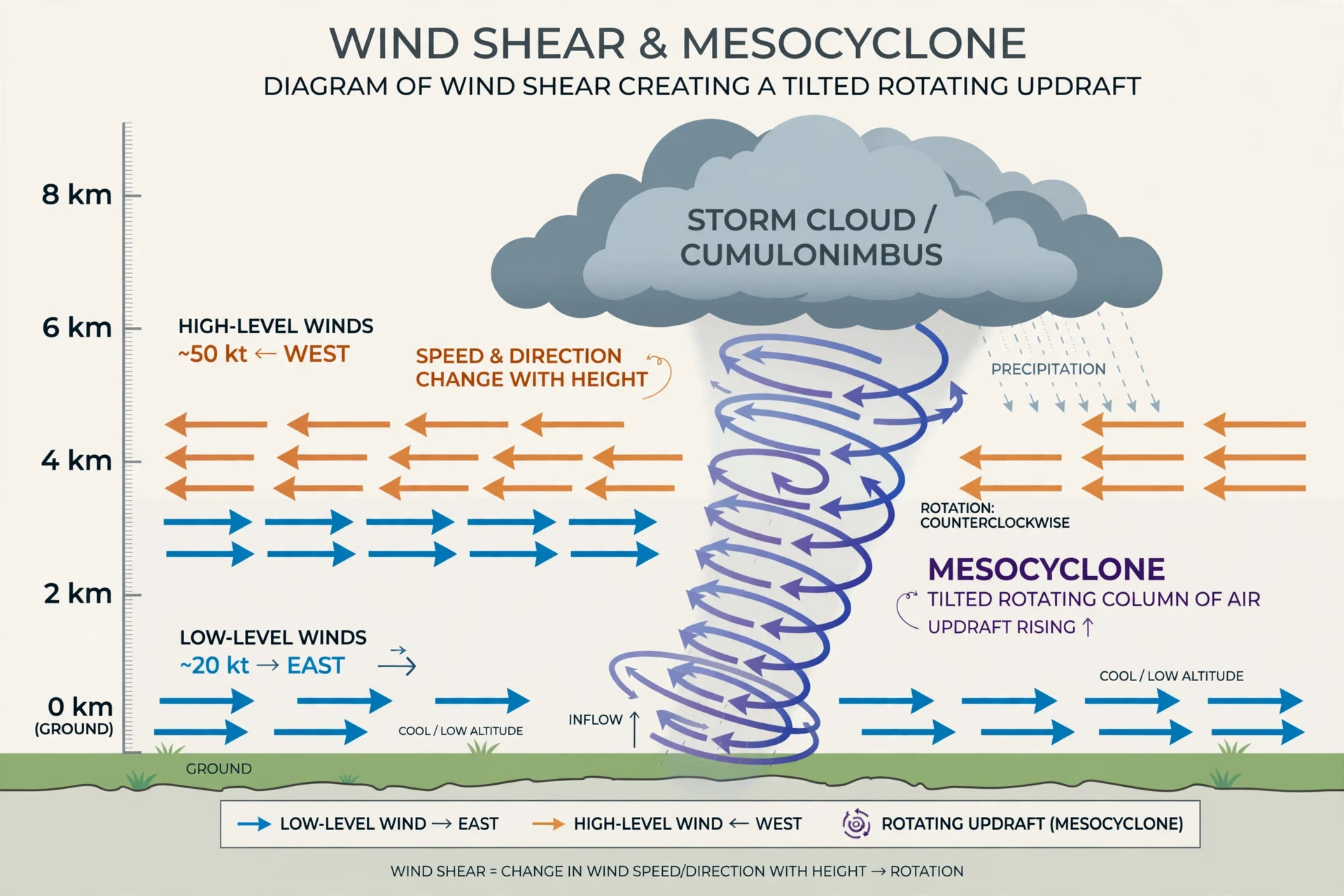
Wind shear is the fourth ingredient, and it is the one that separates a tornado day from an ordinary thunderstorm day. Wind shear is a change in wind speed, or wind direction, or both, with height. Near the ground, winds might blow gently from the south. A mile up, they might blow harder from the southwest. Three miles up, they might blow much harder from the west. That twisting, speeding-up-with-height pattern is shear, and it does something remarkable to rising air: it makes it spin.
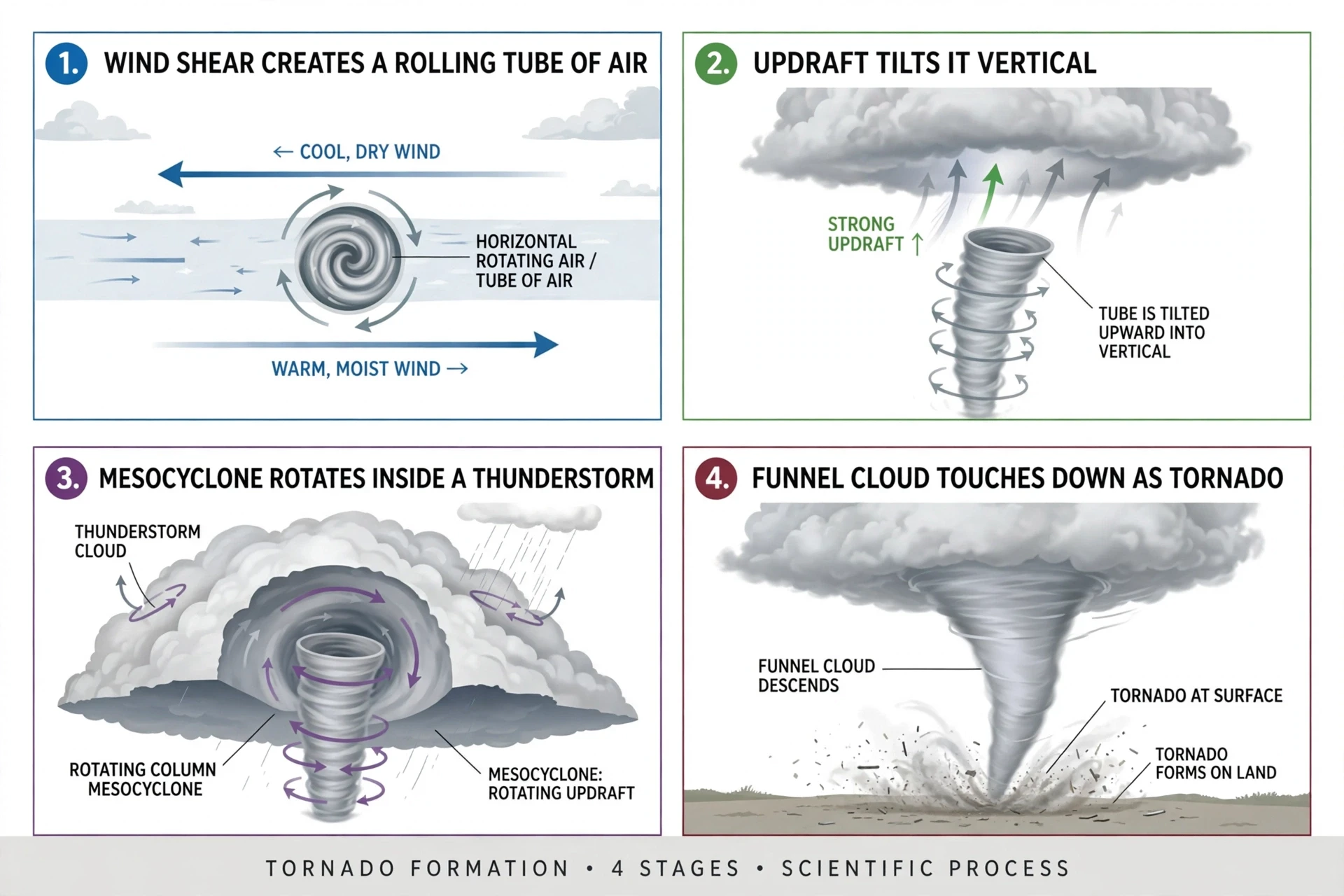
Picture a rolling pin lying on a table. If you push the top of it one way and the bottom the other way, it rolls. Wind shear does the same thing to air. When winds at different heights blow in different directions, the air between them starts to roll — a horizontal tube of spinning air, invisible, a few thousand feet above the ground. On its own, that rolling tube does nothing. But when a thunderstorm's updraft rises through it, the updraft grabs the middle of the tube and lifts it, tilting it from horizontal to vertical, the way you might lift the middle of a skipping rope until both ends hang down. Now the spin is vertical, and the updraft is rotating. That rotating updraft is the heart of a supercell thunderstorm, and it is called a mesocyclone. Almost every violent tornado is born inside a mesocyclone. Without shear, there is no mesocyclone. Without a mesocyclone, there is almost never a violent tornado.
The atmosphere does not make tornadoes by accident. It makes them when four separate ingredients arrive in the same place at the same time — warm, moist air below, cold air above, a trigger to lift the warm air, and wind that changes with height. Remove any one, and the recipe fails.
3. How Tornadoes Form, Step by Step
A tornado is not born in a single moment. It is built, stage by stage, inside a thunderstorm that is itself growing and changing. The sequence below describes the classic case — a supercell thunderstorm, the long-lived, rotating storm that produces the most violent tornadoes. Not every tornado follows this script exactly, and researchers still argue about some of the details, especially the final step, when rotation at cloud level reaches down to the ground. But the broad outline is well established, and it is worth following in order, because each step depends on the one before it.
3.1 A thunderstorm grows up
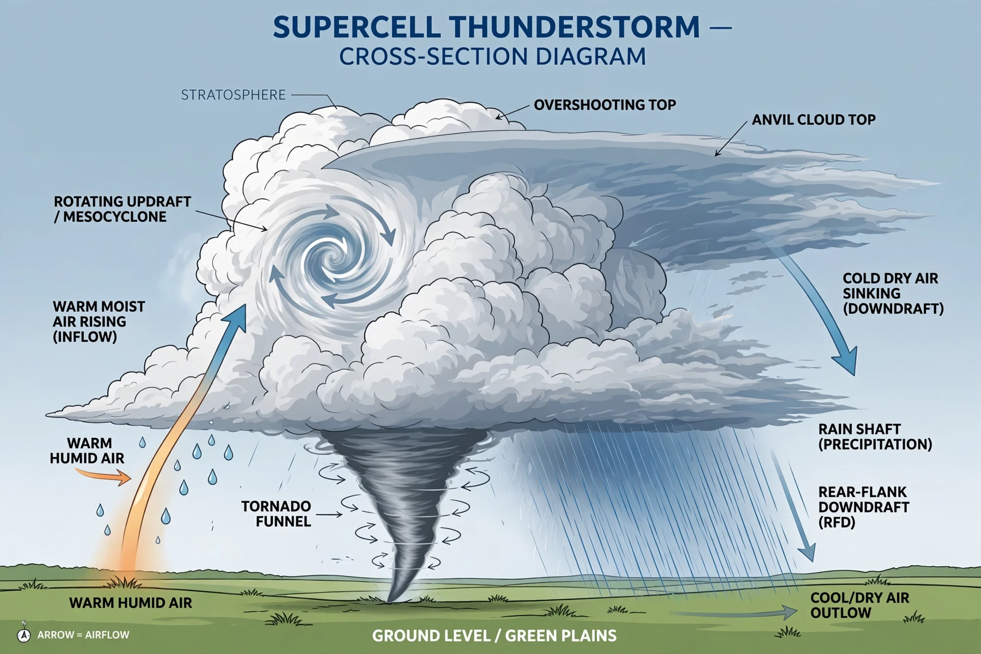
It starts with an ordinary thunderstorm. Warm, moist air rises, cools, and condenses into a cumulus cloud that grows upward through the afternoon. In a normal thunderstorm, the rising air and the falling rain share the same column, so the rain eventually falls into the updraft, cools it, and chokes it off. The storm rains itself out in half an hour or so. A supercell is different, because wind shear separates the updraft from the downdraft. The rain falls downwind of the rising air, so the updraft is never choked. The storm can keep feeding on warm, moist air for hours, growing ten miles tall and tens of miles wide, and it can travel for hundreds of miles across the Plains while staying strong. Supercells are rare — only a small fraction of thunderstorms become supercells — but they produce a large share of the most destructive tornadoes, along with the biggest hail and the strongest straight-line winds.
The supercell has a shape you can learn to recognise. From the side, it looks like a vast anvil: a towering cloud with a flat top that spreads out where the rising air hits the top of the troposphere, the lowest layer of the atmosphere, and can rise no further. From below, the base of the storm is dark and flat, and on the southwestern side of that base — in the Northern Hemisphere, where storms usually move from southwest to northeast — there is often a lower, darker, rotating section called a wall cloud. A wall cloud is a lowering of the cloud base where air is rotating and being pulled upward. It is the part of the storm to watch. Most tornadoes, when they form, form from a wall cloud.
3.2 Shear sets the air rolling
The second step is the one we met in the last section: wind shear creates a horizontal rolling tube of air. This happens before the storm is even visible as a supercell, in the clear air ahead of it. Winds near the ground blow from the south, carrying Gulf moisture. Winds higher up blow from the west or southwest, faster. The difference in speed and direction makes the air between them roll, like a barrel turning slowly over and over. You cannot see this rolling air — it is invisible, and it is happening thousands of feet above the ground — but it is the raw material of rotation. Without it, the storm that follows would rise straight up and rain itself out like any ordinary thunderstorm.
Forecasters look for this shear in weather balloon soundings, which measure wind speed and direction at every height above a launch site. A sounding that shows winds turning and strengthening with height, over a layer of warm, moist surface air, is a sounding that makes a forecaster sit up. It is not a tornado forecast by itself, but it is the first sign that the atmosphere is capable of making one.
3.3 The updraft tilts the spin upright
The third step is the tilt. As the thunderstorm's updraft grows, it rises through the layer of rolling air and lifts the middle of the horizontal tube, bending it upward. The tube becomes a vertical column of spinning air, and the spin is now in the same direction as the updraft — upward and rotating. This rotating updraft is the mesocyclone, and it can be several miles wide, far wider than the tornado that may eventually form inside it. The mesocyclone is the storm's engine and its signature. On Doppler radar, it shows up as a couplet: winds blowing toward the radar on one side and away from it on the other, side by side, marking the rotation.
3.4 The spin tightens and stretches down
The fourth step is where the tornado itself is born, and it is the step scientists understand least. Inside the mesocyclone, rotation begins to concentrate into a smaller, faster-spinning core. Think of an ice skater pulling her arms in: as the radius shrinks, the spin speeds up. The same physics — conservation of angular momentum — applies to air. As the rotating column narrows, it spins faster. At the same time, the rotation stretches downward, from the cloud base toward the ground, helped by a downdraft of cool air wrapping around the back of the storm, called the rear-flank downdraft. This downdraft brings rotation down to the surface and sharpens the contrast between the rising warm air and the sinking cool air.
A funnel cloud appears when the pressure inside the tightening spin drops enough for water vapour to condense. At first the funnel is a small, ragged nub hanging from the wall cloud. Then it lengthens, reaching down, sometimes in stages — growing, retreating, growing again — while spotters and radar watch and hold their breath. In many storms, the funnel never reaches the ground. It hangs for a few minutes and dissolves. In others, it reaches down steadily, and the moment it touches the ground, or the moment a debris cloud rises to meet it, a tornado exists. That moment can be hard to pin down from a distance, which is why tornado start times in the official record are approximate, and why the same tornado can be reported as starting in two different places by two different observers.
3.5 Why most storms never make one
That failure rate is worth pausing on, because it explains something important about tornadoes: they are hard to make. Even on a day when the ingredients look perfect — warm, moist air, strong shear, a powerful supercell — most storms do not produce a tornado. Some produce funnel clouds that never touch down. Some produce mesocyclones that never tighten. Some produce tornadoes that last thirty seconds and damage nothing but a fence. Forecasters can say, with real skill, that tornadoes are likely in a region on a given afternoon. They cannot say which storm, or which town, or which minute. The final step, the tightening and stretching down, depends on small-scale details — the exact temperature of the downdraft, the exact shape of the terrain, the exact timing of one gust against another — that no forecast model and no radar can fully resolve.
4. Not All Tornadoes Are Supercell Tornadoes
The supercell tornado is the most famous kind, and the most destructive, but it is not the only kind. Three other types — landspouts, waterspouts, and gustnadoes — form by different routes, and knowing the difference helps explain why tornadoes appear in places and seasons where supercells are rare, and why some tornadoes are weak while others are violent. They also explain why the word "tornado" covers a wider family than most people realise.
Landspouts form from the ground up, not from the cloud down. They begin when a growing cumulus cloud passes over a boundary on the ground — a line where winds meet, or where the temperature changes sharply — and the rising air under the cloud starts to spin, the way dust spins up in a dust devil. The spin stretches upward until it connects with the cloud base. Landspouts are usually narrow, rope-like, and weak, though a strong one can damage roofs and trees. They are common on the High Plains in summer, where the air is dry and the clouds are smaller, and they often appear on days when nobody would expect a tornado, because there is no supercell and no mesocyclone. I once watched a landspout form over a freshly ploughed field in Colorado, a thin, pale rope of dust rising to meet a small cloud, lasting less than a minute, and vanishing as if it had never been there. The farmer whose field it crossed shrugged when I asked him about it. "We get those," he said. "They don't count." He meant they don't count as the kind of tornado that destroys a town. He was right — and also, in the official record, wrong. They do count. They are tornadoes, just small ones.
Waterspouts are tornadoes over water, and they come in two kinds. Tornadic waterspouts are simply supercell tornadoes that happen to form over water, or move from land out over water, and they can be just as violent as any land tornado. Fair-weather waterspouts are different: they form from the water up, like landspouts, under a growing cumulus cloud on a calm, humid day, usually in tropical and subtropical waters. They are common off the Florida Keys, in the Gulf of Mexico, and in the Mediterranean. A fair-weather waterspout looks dramatic — a bright, twisting column of spray over blue water — but it is usually weak, moves slowly, and dies when it reaches land. Even so, it deserves respect. A waterspout that comes ashore can damage boats, piers, and beachfront buildings, and people on the water should move away from one, not toward it for a photograph.
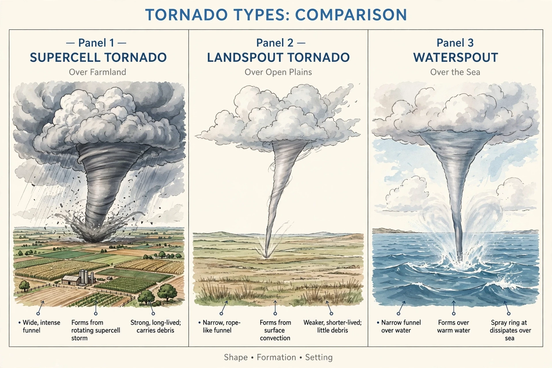
The table below sums up the family at a glance. Keep it in mind when you read tornado reports: the word "tornado" is a category, not a single thing, and the category covers everything from a thirty-second landspout over an empty field to a mile-wide wedge that stays on the ground for an hour.
Type | How it forms | Typical strength | Where it is common |
|---|---|---|---|
Supercell tornado | Inside a rotating mesocyclone in a supercell thunderstorm | Weak to violent (EF0 to EF5) | Great Plains, Southeast United States |
Landspout | Spin grows upward from a ground boundary under a growing cloud | Usually weak (EF0 to EF1) | High Plains, summer afternoons |
Tornadic waterspout | Supercell tornado over water or moving offshore | Weak to violent | Coastal waters near supercell storms |
Fair-weather waterspout | Spin grows upward from warm water under a cumulus cloud | Usually weak (EF0) | Florida Keys, Gulf of Mexico, Mediterranean |
Gustnado | Spin along the gust front of a thunderstorm | Very weak, very brief | Anywhere thunderstorms occur |
5. The Enhanced Fujita Scale: How Tornadoes Are Rated
When a tornado is reported, one of the first questions people ask is, "How strong was it?" The answer comes from the Enhanced Fujita scale, usually shortened to the EF scale, and it is a measure with a twist: it does not measure wind speed directly. It measures damage, and then works backward from the damage to estimate the wind speed that must have caused it. The reason is practical. In almost every case, nobody was standing inside the tornado with an anemometer. What survives is the damage — the roofs, the trees, the walls — and the damage is the evidence.
The original Fujita scale was devised in the 1970s by Ted Fujita, a meteorologist at the University of Chicago whose damage surveys set the standard for the field. It rated tornadoes from F0 to F5 based on the damage they caused. In 2007, the United States replaced it with the Enhanced Fujita scale, which kept the same six categories but tied each one to a much more detailed set of damage indicators — 28 different kinds of structures and trees, from small barns and single-family homes to schools, hospitals, and hardwood trees, each with its own degrees of damage. A survey team walks the path after a tornado, looks at what was damaged and how badly, and assigns a rating based on the worst damage found. The Enhanced Fujita scale is published by the Storm Prediction Center, and its wind-speed ranges are estimates of three-second gusts, not sustained winds.
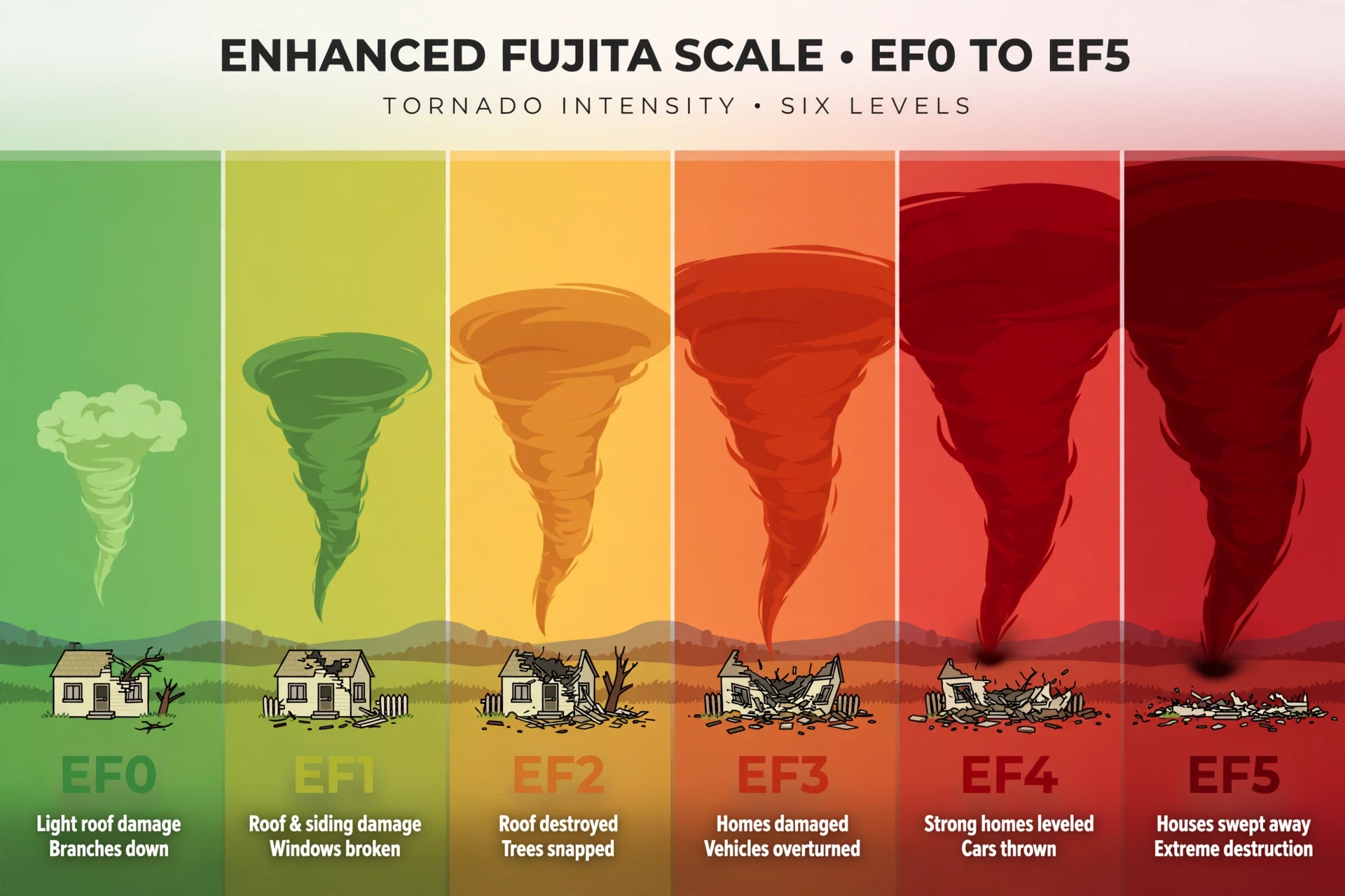
The table below gives the headline numbers. Read it with two cautions in mind. First, the wind speeds are estimates, and they carry uncertainty — a house that was poorly built can be destroyed by weaker winds than a well-built house, and survey teams have to judge the quality of construction before they can judge the wind. Second, the scale is not linear in damage. The jump from EF3 to EF4 is not a small step. It is the difference between a roof torn off and a house swept clean off its foundation.
Rating | Estimated wind speed | Typical damage |
|---|---|---|
EF0 | 65–85 mph | Shingles peeled, gutters damaged, branches broken, shallow-rooted trees pushed over |
EF1 | 86–110 mph | Roof surfaces peeled off, mobile homes pushed off foundations, windows broken, trees snapped |
EF2 | 111–135 mph | Roofs torn off houses, mobile homes destroyed, large trees snapped or uprooted, cars lifted |
EF3 | 136–165 mph | Entire stories of well-built houses destroyed, trains overturned, heavy cars thrown, trees debarked |
EF4 | 166–200 mph | Well-built houses levelled, cars thrown long distances, large debris carried far from its source |
EF5 | Over 200 mph | Strong frame houses swept away, reinforced concrete structures damaged, cars carried through the air |
5.1 What the rating can and cannot tell you
The EF scale is a damage scale, and that creates a problem that confuses people every year: a tornado that crosses open country, damaging nothing but grass and fences, may be rated EF0 or EF1 even if its winds were far stronger, simply because there was nothing there to damage. A tornado's rating is therefore a lower bound on its strength, not a direct measurement of it. The strongest tornado ever measured by mobile radar, in 1999, was rated EF5 — but its measured winds were well above the EF5 threshold, and the scale has no category above EF5 to describe them. The scale was built for damage, and damage is what it measures well. Wind is what it estimates, and estimates have limits.
Most people assume that a higher rating always means a bigger tornado, but the data tells a different story. Width and strength are related — the widest tornadoes tend to be strong — but the relationship is loose. Some of the narrowest tornadoes on record were violent, and some of the widest were weak for most of their lives. What matters is not the size of the column, but the speed of the spin inside it, and the spin is invisible. The funnel you see is the cloud. The wind you fear is inside it, and it can be far faster than the funnel's size suggests.
5.2 The survey: reading a damage path like a book
After a tornado, survey teams from the National Weather Service walk or drive the damage path, often with the help of aerial photographs and, increasingly, drone footage. They look for the start and end of the path, its width at different points, the direction of fallen trees — which shows the direction of the wind at each spot — and the worst damage to each type of structure. They photograph everything, measure what they can, and compare what they see with the EF scale's damage indicators. A house with its roof gone but its walls standing is a different rating from a house with its walls gone and only the foundation left. A hardwood tree snapped halfway up is a different indicator from a softwood tree uprooted whole.
6. Tornado Alley and Where Tornadoes Strike
Ask almost anyone where tornadoes happen, and they will say "Tornado Alley." They are right, but the answer is more interesting — and more worrying — than the phrase suggests. Tornado Alley is not an official boundary drawn on a map. It is a nickname for the stretch of the central United States where tornadoes are most frequent: roughly Texas, Oklahoma, Kansas, Nebraska, and parts of South Dakota, Iowa, and Missouri. The region earns its name because it is where the ingredients we met earlier come together most reliably: warm, moist air from the Gulf of Mexico flows north, cold, dry air slides in from the Rockies and from Canada, and the jet stream passes overhead, providing lift and shear. The land helps, too. The Great Plains are flat, so there is nothing to break up the flow of air, and the ground heats evenly in the spring sun, feeding the instability that powers supercells.
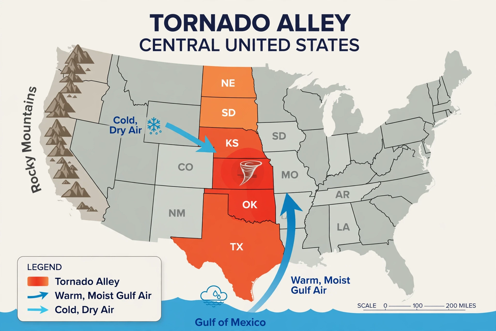
But Tornado Alley is only the most famous part of the map. Tornadoes occur in all fifty states, and the geography of risk is shifting in ways that matter. The Southeast — a region researchers call Dixie Alley, covering parts of Mississippi, Alabama, Tennessee, Georgia, and the surrounding states — has fewer tornadoes than the Plains, but more tornado deaths. The reasons are sobering. Tornadoes in the Southeast are more likely to strike at night, when people are asleep and cannot see the sky. They are more likely to be hidden by rain and by hills and trees, so they are harder to spot. They strike in a region with more mobile homes, more trees that can fall on houses, and a longer tornado season that starts in late winter. A tornado at 2 a.m. in a forested, hilly landscape is a different and more dangerous event than the same tornado at 4 p.m. on the open Plains, and the death toll reflects that.
6.1 Seasons, days, and hours
Tornadoes have a calendar, and it runs on the clash of seasons. In the southern Plains, the peak is late spring, roughly April through June. In the northern Plains, it shifts later, into June and July. In the Southeast, the peak comes earlier, in late winter and early spring, and a second, smaller peak can arrive in the autumn, when tropical systems and cold fronts interact. The pattern follows the warm, moist air as it pushes north through the year and retreats south again. Wherever the boundary between warm and cold air sits, tornadoes follow.
They also have a clock. Most tornadoes form in the late afternoon and early evening, roughly between 3 p.m. and 9 p.m., when the ground has had all day to heat up and the instability is at its peak. That is the good news: the most dangerous hours are also the hours when people are awake, looking at the sky, and able to act on a warning. The bad news is the exception. Night-time tornadoes, though less common, kill a disproportionate share of tornado victims, because people are asleep, because it is dark, and because a tornado at night is invisible until it is on top of you. If you live in tornado country, the single most important safety device you own may be the one that can wake you up: a weather radio with an alarm, or a phone with wireless emergency alerts switched on. We will come back to that in the safety section, because it saves lives in a way that no amount of storm knowledge can replace.
A tornado at 2 a.m. is a different event from the same tornado at 4 p.m. Darkness takes away the one warning the sky itself gives you — the sight of the funnel — and leaves you with only the siren, the radio, and the phone in your pocket. Make sure at least one of those can wake you.
7. How Tornadoes Are Detected and Forecast
Tornado forecasting works on two time scales. Days in advance, forecasters at the Storm Prediction Center issue outlooks that mark the regions where severe weather — including tornadoes — is most likely. These outlooks use computer models, weather balloon data, and the forecaster's judgement to say where the ingredients will come together. A day or two ahead, the outlook narrows to a smaller area. On the day itself, local National Weather Service offices take over, watching radar and reports from trained spotters as storms develop.
The key tool is Doppler radar, which does not just show where rain is falling — it shows how the rain and the air are moving. When a mesocyclone rotates, one side moves toward the radar and the other moves away, and the radar displays that as a pair of bright colours side by side, a velocity couplet. When the couplet tightens and a hook-shaped echo appears — the classic hook echo, where rain wraps around the rotating updraft — forecasters know a tornado may be forming. When a tornado is on the ground, it lifts debris into the air, and the radar sees that debris as a bright spot called a debris ball.
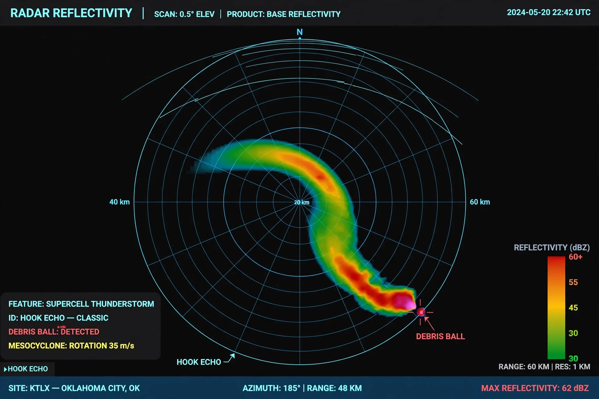
Radar cannot see everything. It scans at an angle, so its beam passes over the lowest part of the atmosphere at a distance, and it cannot see a tornado hidden behind a hill or below the beam. That is why human spotters still matter. Trained volunteers — part of the SKYWARN network — watch the sky, report what they see, and confirm what the radar suggests. A radar signature plus a spotter report is a far stronger basis for a warning than either one alone. Satellites help, too, by showing the big picture: the clouds, the moisture, and the temperature patterns that set the stage. NASA's Earth science missions observe the atmosphere from orbit, and their data feeds into the models forecasters use every day.
7.1 Watch versus warning
The two words people confuse most are "watch" and "warning," and the difference saves lives. A tornado watch means conditions are favourable for tornadoes in the area. It covers a large region and lasts for hours. It is the time to review your plan, check your shelter, and keep an eye on the sky. A tornado warning means a tornado has been spotted, or radar shows one is likely on the ground. It covers a small area — usually a county or part of a county — and it means act now. Get to shelter immediately. The National Weather Service explains the difference plainly: a watch means be prepared, a warning means take action. If you remember nothing else from this article, remember that.
8. What Tornado Damage Really Looks Like
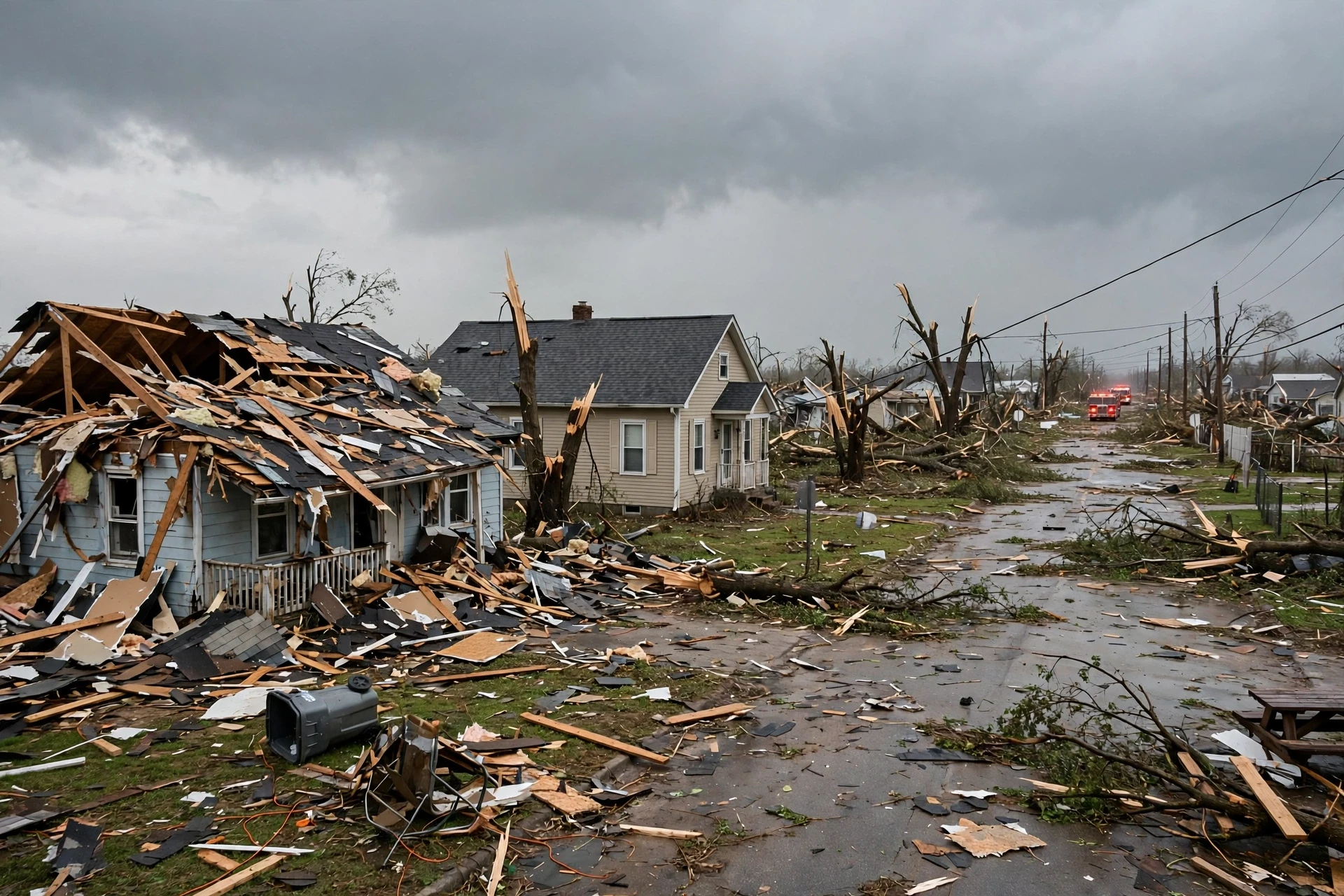
Tornado damage is not like flood damage or fire damage. It is wind damage, and wind damage is chaotic. The wind in a tornado does not push in one direction. It spirals, it gusts, it lifts, and it throws debris — and the debris becomes a weapon. Most tornado injuries are caused not by the wind itself but by flying debris: roof tiles, branches, glass, pieces of lumber moving at highway speeds. A house in a tornado's path is attacked from every side at once, and the roof is usually the first thing to fail. Once the roof goes, the walls lose their support and the whole structure can come apart in seconds. That is why building codes in tornado country now pay so much attention to how a roof is fastened to the walls, and the walls to the foundation. A house is only as strong as its weakest connection.
9. Tornado Myths That Can Get You Killed
Some tornado myths are harmless. Some are dangerous. The dangerous ones survive because they sound like common sense, and because they are passed on by people who mean well. Here are the ones that matter most.
Opening windows will save your house. This is the most persistent tornado myth of all, and it is wrong. The idea is that opening windows equalises the pressure inside and outside the house, stopping it from exploding. Houses do not explode from pressure, as we saw in the last section — they are torn apart by wind. Opening windows does nothing to stop that. It wastes time you should spend getting to shelter, and it lets wind and debris into the house. Keep the windows closed and get to the lowest, most interior room you can reach.
The southwest corner of the basement is the safest place. This old piece of advice came from the idea that a tornado's winds would blow debris into the northeast corner of a basement, leaving the southwest corner clear. It is not reliable. Tornadoes approach from any direction, their winds spiral, and debris can land anywhere. The safest place in a basement is under something sturdy — a heavy table or workbench — away from windows, with your head covered. The corner does not matter nearly as much as the cover.
A highway overpass is a safe shelter. It is not. It is one of the most dangerous places you can be in a tornado. The shape of an overpass can speed up the wind passing underneath it, like a thumb over the end of a hose, and it offers no protection from flying debris. People have been killed sheltering under overpasses. If you are driving and a tornado is near, do not stop under an overpass. Drive away from it if you can, at a right angle to its path. If you cannot escape, park away from traffic, keep your seatbelt on, cover your head, or leave the car and lie flat in a low ditch as a last resort, covering your head with your hands.
Tornadoes cannot cross rivers, hills, or cities. They can, and they have. Tornadoes have crossed the Mississippi River, climbed hills, and struck the centres of major cities. Water does not stop them. Hills do not stop them. Buildings do not stop them. The idea that a tornado cannot hit a city is especially dangerous, because it has been disproved many times, most famously when tornadoes struck downtown areas that people had assumed were safe. If a warning covers your city, take it as seriously as you would anywhere else.
Large, dark tornadoes are always the dangerous ones. Size and darkness are poor guides to strength. A tornado's colour comes from the dust and debris it picks up and the light behind it. A thin, pale, almost invisible tornado can be violent. A huge, black wedge can be weaker than it looks. Never judge a tornado by its appearance. Judge it by the warning, and act on the warning.
Most people assume a tornado will look like the ones in the movies — huge, black, and obvious. What the data actually shows is that the most dangerous tornado is often the one you cannot see clearly: hidden by rain, hidden by darkness, or too thin and pale to notice until it is close. Trust the warning, not your eyes.
10. Tornado Safety: Before, During, and After
Tornado safety has three parts, and only one of them happens during the storm. The other two — preparing before tornado season, and knowing what to do after — are where most lives are saved, because they are the parts you can control when the sky is still calm.
10.1 Before the season
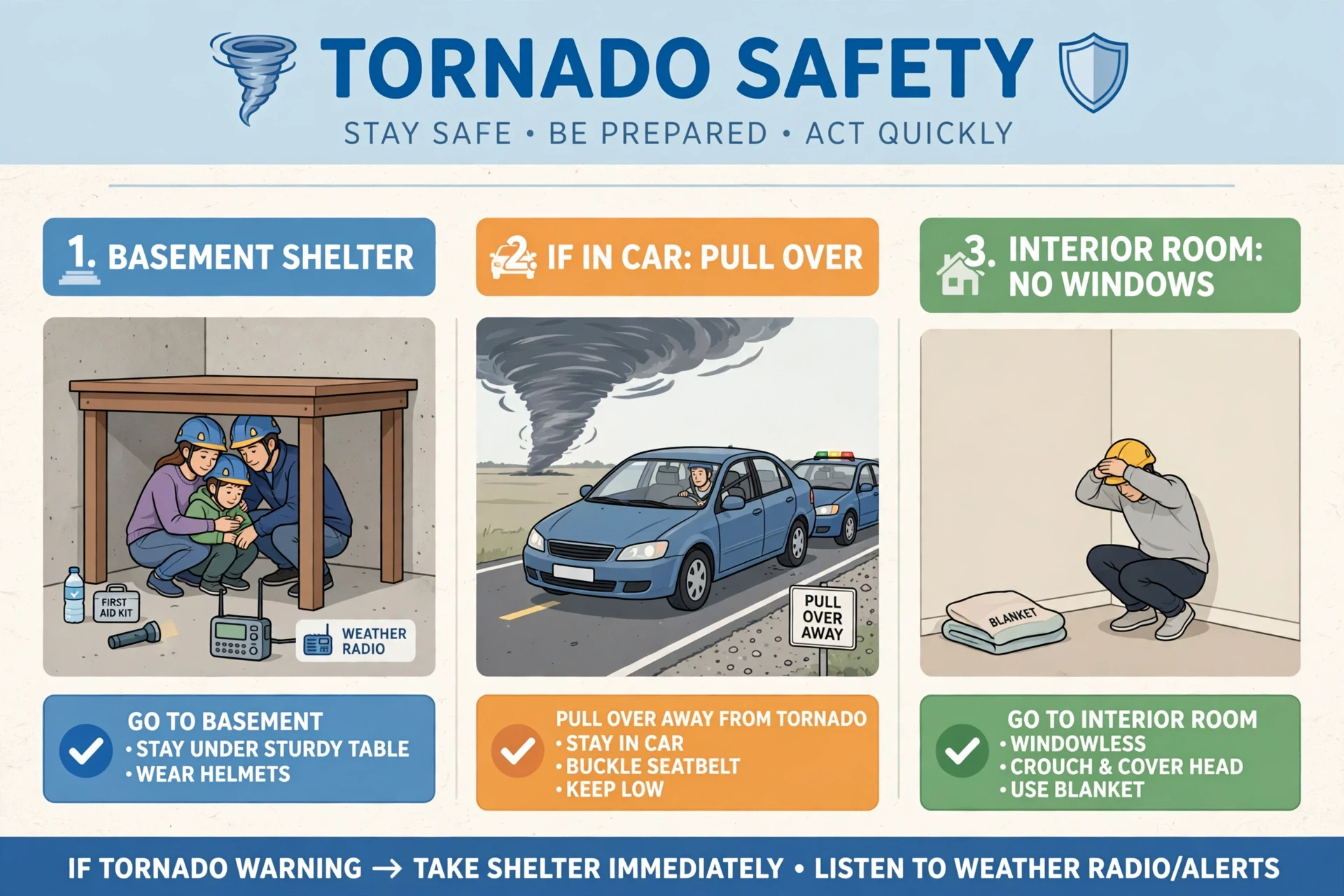
Know your shelter before you need it. In a house, the safest place is the lowest floor, in a small interior room with no windows — a bathroom, a closet, or a hallway — as close to the centre of the building as possible. A basement is better still, especially under a sturdy table or stairwell. If you have a purpose-built storm shelter or safe room, keep it clear and know how to get into it quickly. If you live in a mobile home, identify a sturdy building nearby where you can shelter, and plan to go there early, because a mobile home offers almost no protection in a tornado, even a weak one.
Make a plan and practise it. Everyone in the household should know where to go and how long it takes to get there. Put together a small kit — a weather radio with fresh batteries, a flashlight, water, a first-aid kit, sturdy shoes, and a helmet or a mattress to protect your head — and keep it in or near your shelter. Sign up for alerts: a NOAA weather radio with an alarm, and wireless emergency alerts on your phone.
10.2 When a warning sounds
When a tornado warning is issued for your area, go to shelter immediately. Do not wait to see the tornado. Do not go outside to look. Do not try to film it. In your shelter, crouch low, cover your head and neck with your arms, a helmet, a mattress, or heavy blankets, and stay there until the warning expires or you are told it is safe. If you are in a car and cannot drive away from the tornado, park, keep your seatbelt on, and cover your head, or leave the car and lie flat in a low spot as a last resort. Never shelter under an overpass. If you are outside with no shelter, lie flat in the lowest place you can find, away from trees and cars, and cover your head.
The National Weather Service tornado safety page and the federal Ready.gov tornado guide both give the same advice. Read them in full before tornado season starts, not during it.
10.3 After the tornado passes
Wait until you are sure the danger has passed. Tornadoes sometimes come in families, and a second tornado can follow the first along a similar path. When you leave shelter, watch for hazards: downed power lines, broken gas lines, sharp debris, and damaged buildings that may collapse. Do not enter a badly damaged building, check on neighbours, and trust official sources — the National Weather Service and local emergency management — for news about roads, shelters, and aid.
11. Tornadoes and a Changing Climate
The question of whether climate change is affecting tornadoes is one of the most active debates in weather science, and the honest answer is that the picture is still coming into focus. Reported tornado numbers have risen over the decades, but most of that rise is explained by better detection: Doppler radar, more spotters, and more cameras. The number of violent tornadoes has not shown a clear long-term trend. What has changed is the pattern: tornado activity appears to be shifting eastward, away from the traditional Tornado Alley and toward the Southeast and the Midwest, and tornadoes are clustering more into outbreak days, with quieter stretches in between. NOAA's collection on tornadoes is a good place to follow this research as it develops. The physics points in two directions at once: a warmer atmosphere holds more moisture, which increases instability, but a warmer Arctic may weaken the jet stream and reduce wind shear. Which effect wins, and where, is not yet settled. What is settled is that tornadoes will remain a threat wherever the ingredients meet, and that preparation protects people whatever the climate does. If you want the bigger picture, our guide to climate change explains how a warming atmosphere changes weather in general, and our guide to meteorology explains how forecasts are made.
The physics points in two directions at once, which is why the debate is genuine. A warmer atmosphere holds more moisture, which increases instability and the energy available to thunderstorms. That argues for more severe weather. But a warmer Arctic may weaken the jet stream and reduce wind shear, which argues for fewer tornadoes. Which effect wins, and where, is not yet settled. Anyone who tells you the science is settled on tornadoes and climate change is oversimplifying. What is settled is that tornadoes will remain a threat wherever the ingredients meet, and that preparation — warnings, shelters, building codes — protects people whatever the climate does. If you want to understand the bigger picture, our guide to climate change explains how a warming atmosphere changes weather in general, and our guide to meteorology explains how forecasts are made in the first place.
12. Learning to Read the Sky
The first time I watched a wall cloud turn, I thought I was watching something rare and strange. I have since learned that I was watching something ordinary and extraordinary at the same time: ordinary, because the ingredients that make a tornado are the same ingredients that make an afternoon thunderstorm; extraordinary, because so much has to go right — or wrong — for those ingredients to line up. A tornado is the atmosphere at its most concentrated: all the heat of a summer afternoon and all the moisture of a distant sea, squeezed into a column of air narrower than a street.
That is why tornadoes deserve more than fear. They deserve understanding. Understand the ingredients, and you can understand the forecast. Understand the forecast, and you can understand the warning. Understand the warning, and you know what to do in the minutes that matter. The tools exist. The science exists. The rest is a plan, practised before the season, and followed without hesitation when the siren sounds.
If you take one idea from this guide, let it be this: a tornado is not a mystery. It is a machine with parts you can name, steps you can follow, and a warning system you can trust. The next time the sky turns that bruised green and the air goes still, you will know what is happening above your head — and, more importantly, what to do about it.
Frequently Asked Questions
How do tornadoes form?
Tornadoes form inside thunderstorms when warm, moist air near the ground, cold air above, a lifting trigger, and wind shear all come together. Wind shear sets the air rolling, the updraft tilts that spin upright into a mesocyclone, and the rotation tightens and stretches downward until a funnel cloud touches the ground.
What is the difference between a tornado watch and a tornado warning?
A tornado watch means conditions are favourable for tornadoes in a large area over several hours — be prepared and keep watching the sky. A tornado warning means a tornado has been spotted or radar shows one is likely on the ground in a small area — take shelter immediately. The National Weather Service explains the difference in the same terms: watch means be prepared, warning means act now.
What is Tornado Alley?
Tornado Alley is the nickname for the central United States — roughly Texas, Oklahoma, Kansas, Nebraska, and nearby states — where tornadoes are most frequent. Warm, moist air from the Gulf of Mexico meets cold, dry air from the west and north over the flat Great Plains, with the jet stream overhead providing lift and shear. A second high-risk region, Dixie Alley in the Southeast, has fewer tornadoes but more deaths, partly because its tornadoes often strike at night.
How strong can a tornado get?
The strongest tornadoes, rated EF5 on the Enhanced Fujita scale, have estimated winds above 200 miles per hour, and Doppler radar has measured winds above 300 miles per hour in the most extreme cases. Most tornadoes are far weaker — the great majority are EF0 or EF1, with winds between about 65 and 110 miles per hour.
Can tornadoes happen at night?
Yes, and night-time tornadoes are especially dangerous. They kill a disproportionate share of tornado victims because people are asleep, it is dark, and the funnel cannot be seen. A weather radio with an alarm or a phone with wireless emergency alerts switched on is the most important protection at night.
Is it safe to shelter under a highway overpass during a tornado?
No. An overpass is one of the most dangerous places to be in a tornado. Its shape can speed up the wind underneath it, and it offers no protection from flying debris. If you are driving, drive away from the tornado if you can. If you cannot, park away from traffic and cover your head, or lie flat in a low ditch as a last resort.
Why is the sky sometimes green before a tornado?
A green sky is often reported before severe thunderstorms and tornadoes, and it is linked to the way sunlight scatters through a deep, water-laden storm cloud — the same scattering that makes the sky blue on a clear day, as explained in our guide to why the sky is blue. A green sky is a sign of a powerful storm, but it is not a guarantee of a tornado, and a tornado can form without any green sky at all. Treat it as a reason to pay attention, not as a forecast by itself.
Sources
NOAA Storm Prediction Center — tornado outlooks, forecasts, and the Enhanced Fujita scale.
NOAA Storm Prediction Center, Tornado FAQ — answers to common questions about tornadoes.
Enhanced Fujita Scale, Storm Prediction Center — the EF scale damage indicators and wind-speed estimates.
National Weather Service, Tornado Safety — what to do before, during, and after a tornado.
National Weather Service, Tornado Watches and Warnings — the difference between a watch and a warning.
NOAA Education, Tornadoes — background on tornado science and climate research.
Ready.gov, Tornadoes — federal guidance on preparing for tornadoes.
NASA — Earth science missions that observe the atmosphere from orbit.