

I was twelve when I first got properly caught in a monsoon downpour — my first real lesson in how rain works. It was late afternoon, the air had been thick and still all day, and the sky to the west had turned the colour of bruised plums. My friends and I were playing cricket in a field a ten-minute walk from home, and we all agreed, with the confidence only twelve-year-olds have, that the rain would hold off. Then the wind changed. It came in one cool gust that smelled of wet earth, the light dropped as if someone had pulled a curtain, and the rain arrived — not as a drizzle that built up, but as a wall of water. Within thirty seconds we were soaked to the skin, laughing and shouting, running for shelter under a tin-roofed tea stall while the rain hammered the roof so loudly we had to shout to hear each other. The field we had been standing on turned into a shallow lake in minutes. The ditch beside the road, dry and dusty that morning, was suddenly a brown river carrying leaves and bottle caps.
That afternoon taught me something I have spent years unlearning and relearning as a science writer: rain is not simple. It looks simple — water falls from the sky, the ground gets wet — but every drop that hits your face is the end of a journey that began somewhere else entirely, possibly hundreds of kilometres away and days earlier, possibly as water in an ocean you have never seen. To understand how rain works is to understand how the whole planet moves water around: how the Sun lifts it off the sea, how the wind carries it, how invisible vapour becomes a cloud, how a cloud too small to see becomes a drop heavy enough to fall, and why that drop falls on your town and not on the desert a few hundred kilometres away.
This guide follows one drop of water through that whole journey. We will start with the water cycle, look inside a cloud to see how droplets grow, meet the four ways air gets lifted into the sky, sort out the different kinds of rain, and answer the questions people actually ask — why raindrops are not teardrop-shaped, why some places drown while others stay dry, and what a changing climate is doing to rain. By the end, the next time you hear rain on a roof, you will hear a story in it.
1. What Rain Actually Is
Rain is liquid water falling from clouds to the ground. That definition sounds obvious, but it hides a puzzle: clouds are made of water too, so why does water fall from a cloud at all, and why does it fall as rain rather than as a slow, floating mist?
The answer is size. A cloud is a crowd of tiny water droplets or ice crystals, each one so small — about a hundredth of a millimetre across — that it falls almost imperceptibly slowly, slower than the air around it rises. A cloud droplet falls at roughly a centimetre per second, which is slower than a feather drifting down. The air inside a cloud is usually rising faster than that, so the droplets stay up, floating, and the cloud holds together. Rain begins when those droplets grow large enough that gravity finally wins. A typical raindrop is about a millimetre across — a hundred times wider than a cloud droplet, and a million times heavier. At that size it falls at several metres per second, fast enough to punch through the rising air and reach the ground.
That size gap is the whole story of rain in one sentence: rain is what happens when cloud droplets grow about a million times heavier. Everything else — the water cycle, the cloud types, the weather fronts, the mountains that squeeze rain out of the sky — is about how that growth happens, and where, and why it sometimes fails.
It is worth clearing up one confusion right away. The water vapour that rises from a warm sea is invisible. When you see steam curling off a kettle, you are not seeing water vapour — you are seeing the vapour after it has cooled and condensed into tiny liquid droplets. The same is true of clouds. A cloud is not a bag of invisible vapour. It is a visible crowd of liquid droplets or ice crystals, floating because they are small and the air is rising. When people say a cloud is "full of water vapour," they are describing the wrong thing, and the mistake matters, because the difference between vapour and droplets is the difference between a gas and a liquid — and rain is a liquid falling out of a crowd of liquids.
Rain is also only one kind of precipitation, the general word for water falling from the sky. Snow, sleet, hail, and drizzle are all precipitation too, and they are all made by the same machinery, with one or two settings changed. Snow is what you get when the droplets freeze and stay frozen all the way down. Hail is what you get when strong updrafts in a thunderstorm keep tossing a lump of ice up and down through a cloud, adding a new layer of ice on every trip, until it is too heavy to hold up. Drizzle is rain that never quite grew up — drops smaller than half a millimetre, falling so slowly they seem to hang in the air. This article is about rain, but we will keep meeting its relatives, because they share the same family history.
2. The Water Cycle: Where Every Drop Comes From
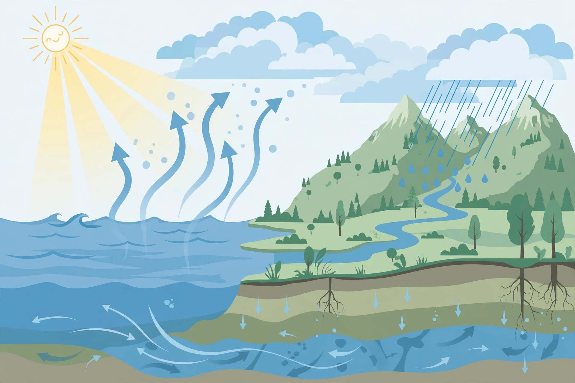
Every drop of rain has been somewhere before. The water in your glass, in the rain on your window, in the river at the bottom of your street — it is the same water that has been cycling around this planet for billions of years. Water does not get used up. It changes form, changes place, and comes back. That loop is the water cycle, and rain is one of its busiest junctions.
The cycle runs on two engines: the Sun and gravity. The Sun provides the energy, evaporating water from oceans, lakes, rivers, and wet soil, and pulling it out of leaves through transpiration — plants breathing water vapour into the air. Gravity provides the return trip, pulling rain back down to the ground, where it flows into rivers, soaks into soil, or runs back to the sea. Between those two engines, the atmosphere acts as a conveyor belt, carrying water vapour around the planet on the wind. You can read the full story of that loop in The Water Cycle, but here is the part that matters for rain: at any moment, the atmosphere holds only a small fraction of Earth's water — about 0.001 percent of it — yet that thin, invisible reservoir is the source of every drop of rain that has ever fallen.
That small number is worth sitting with. The atmosphere is a miserly storehouse. It holds roughly twelve thousand cubic kilometres of water at any one time, and it turns that whole stock over every eight to ten days. The oceans hold about 1.3 billion cubic kilometres. So the sky is a thin pipe, not a tank: water rushes through it, and rain is the tap at the end of the pipe. When the tap runs faster than the pipe refills — during a drought — the land dries out. When the pipe delivers more than the land can absorb — during a flood — the water has nowhere to go.
2.1 Evaporation: the Sun lifts the water
Evaporation is the quiet start of every raindrop. Warm the surface of a lake, and the fastest-moving water molecules at the surface break free and escape into the air as vapour. The Sun does this on a planetary scale: most of the water vapour in the air comes from the oceans, which cover about 71 percent of Earth's surface. Warm tropical seas evaporate enormous amounts of water, and the trade winds carry that vapour away.
Here is a detail that surprises most people, and it matters for understanding rain. Evaporation does not need boiling. It happens at any temperature, even from ice on a cold day, because molecules in a liquid do not all move at the same speed. A few are always moving fast enough to escape. That is why a puddle dries up on a cool afternoon, and why your wet laundry dries on a washing line in winter. Heat speeds evaporation up, but it is not a requirement. The USGS water cycle pages describe this plainly: evaporation is the process by which water changes from a liquid to a gas, and it is the primary way water moves from the land and oceans into the atmosphere.
2.2 Transpiration: plants breathe water into the sky
About a tenth of the water vapour in the air comes not from open water but from plants. A tree pulls water up from the soil through its roots, uses a little of it for photosynthesis, and releases the rest through tiny pores in its leaves called stomata. A single large oak can release hundreds of litres of water into the air on a hot day. A rainforest releases so much water this way that it partly makes its own rain — the Amazon, for instance, recycles much of its rainfall through its trees, and cutting the forest changes the rain itself. This is one reason deforestation is a rainfall problem as well as a wildlife problem: remove the trees, and you remove a pump that puts water back into the sky.
2.3 Condensation: vapour becomes a cloud
Evaporation puts water into the air as an invisible gas. Condensation turns it back into a liquid — and that is where clouds come from. Warm air can hold more water vapour than cold air. So when a parcel of moist air rises and cools, it eventually reaches a point where it can no longer hold all its vapour. The excess vapour condenses onto tiny particles floating in the air — dust, sea salt, smoke, pollen — and becomes liquid droplets. Those particles, called condensation nuclei, are essential. Without them, water vapour struggles to condense at all. Clean, particle-free air can stay supersaturated, holding more vapour than it should, like a room full of people with nowhere to sit. The dust in the air is the furniture.
Rain is not water falling out of an empty sky. It is the last step in a loop that starts with sunlight on the sea, runs through the wind, and ends with gravity pulling a grown-up droplet back to Earth.
3. How Rain Works Inside a Cloud: Droplets, Collisions, and Ice
Clouds look soft and simple from the ground. From the inside, they are busy, crowded places. A single cubic centimetre of cloud — a volume smaller than a sugar cube — can hold hundreds of tiny droplets. And yet a cloud is mostly empty space: the droplets are so small and so spread out that a cloud is, by volume, almost entirely air. A typical cloud droplet is about 10 to 20 micrometres across. A human hair is about 70 micrometres wide. So a cloud droplet is a fraction of a hair's width, and a raindrop is a hundred times wider than that. The question of how rain works is, at its core, the question of how something a fraction of a hair wide becomes something you can feel hit your skin.
I once watched this happen, in a small way, on a mountain hike. I was walking through a cloud — the trail had climbed into the mist, and the world had shrunk to a grey bubble a few metres wide. The air was wet in a way that was not rain: it was a fine, cool dampness that settled on my jacket and my hair without ever forming a drop. Then, as the trail descended, the mist thickened into drizzle, and the drizzle into rain. I had walked through the whole transition, from cloud to rain, in twenty minutes, and the only thing that had changed was that the droplets had grown heavy enough to fall. I have never forgotten how undramatic it was. No thunder, no drama — just small things getting bigger until gravity noticed them.
3.1 Rising air cools — and cooling makes clouds
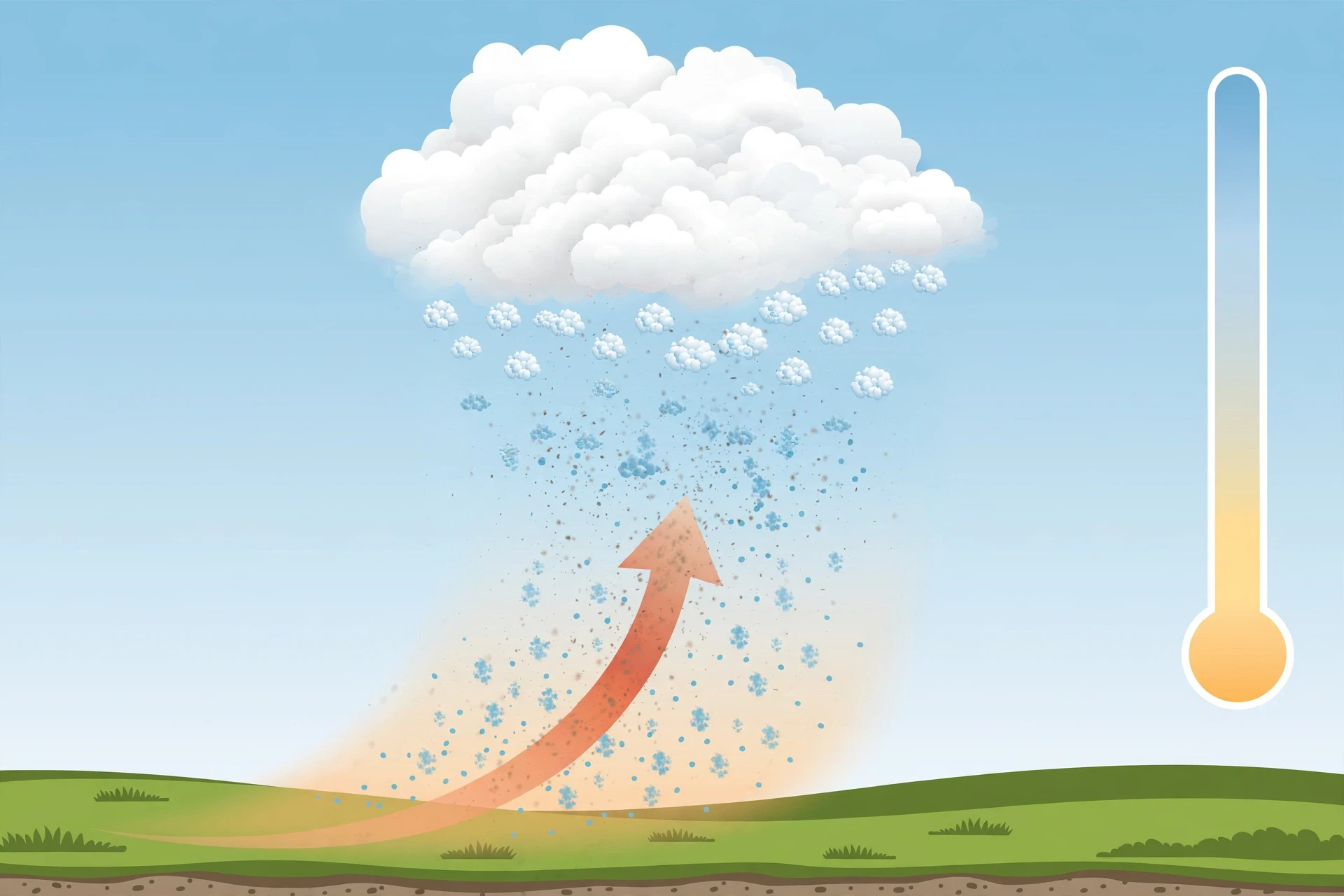
The first step is always the same: air has to rise. Air near the ground is warm and moist. As it rises, the pressure around it drops, the air expands, and expanding air cools — about 6 to 10 degrees Celsius for every kilometre it climbs. Warm air can hold more water vapour than cold air, so as the rising air cools, it eventually hits its dew point, the temperature at which the air is saturated. Past that point, the excess vapour has to go somewhere, and it condenses onto condensation nuclei, forming droplets. The height where this happens is the cloud base — which is why cloud bases often look flat, like the bottom of a table. Every droplet in that cloud started condensing at roughly the same height, where the rising air first hit its dew point.
This is also why clouds form over hills and mountains, why they pile up on hot afternoons, and why they line up along weather fronts. In each case, something is pushing air upward. The details differ, and we will meet them in section 4, but the physics is the same: rise, cool, condense.
3.2 Collision and coalescence: droplets that grow by bumping
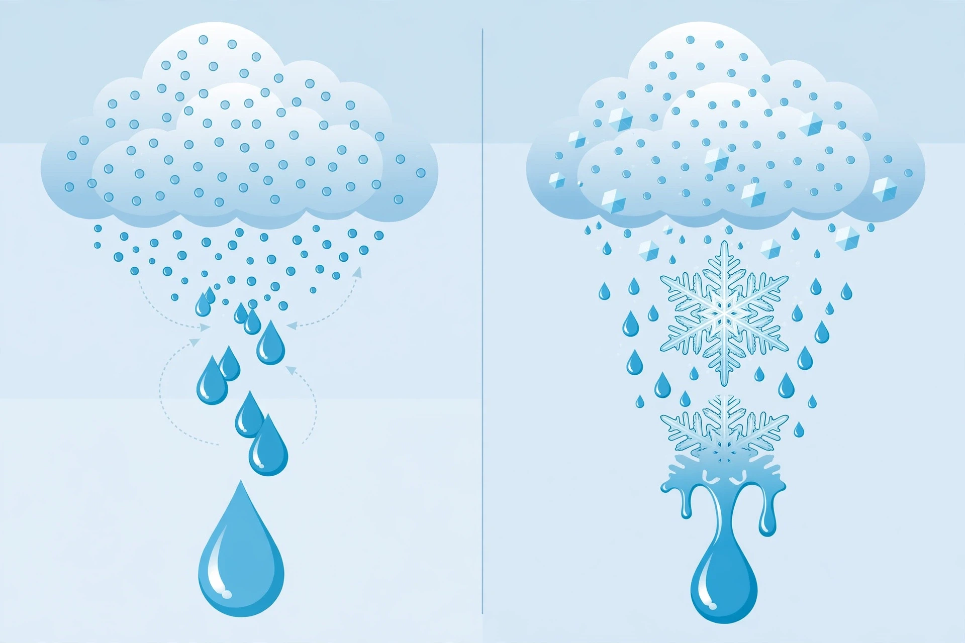
In a warm cloud — one where the temperature stays above freezing all the way through — droplets grow by collision and coalescence. It is a simple, almost clumsy process. Droplets are not all the same size. The bigger ones fall slightly faster than the smaller ones, so they overtake them, bump into them, and merge. Each merger makes the drop bigger, which makes it fall faster, which makes it sweep up more droplets. It is a runaway process: once a droplet gets a head start, it grows quickly. But it is also slow to start, because the droplets are tiny and the cloud is mostly empty space. A droplet has to fall through a long stretch of cloud, collecting neighbours, before it becomes a raindrop. In a warm tropical cloud, this can take twenty minutes or more, and it takes roughly a million cloud droplets to make a single raindrop.
That number — a million droplets for one drop — is the reason warm rain is hard to make. The cloud has to be thick, wet, and long-lived enough for the mergers to add up. Thin clouds, or clouds that dry out quickly, never get there. Their droplets stay small, and the cloud simply evaporates away. If you have ever watched a small white cloud on a summer afternoon slowly fade and vanish without raining, you have watched this failure happen. The droplets were there. They just never grew up.
3.3 The Bergeron process: how ice makes rain in cold clouds
In most of the world, though, rain does not start as liquid at all. It starts as ice. In a cloud that extends high enough for the temperature to drop below freezing, the droplets at the top become supercooled — liquid water that is colder than zero degrees Celsius but has not frozen, because freezing needs a nucleus too, and ice nuclei are rarer than condensation nuclei. Supercooled droplets and ice crystals can sit side by side in the same cloud, and that mixture is unstable in a useful way.
Here is why. The air inside a cloud is saturated with respect to liquid water, but it is supersaturated with respect to ice — because the saturation vapour pressure over ice is lower than over liquid water at the same temperature. In plain language: ice holds onto water vapour more tightly than liquid water does. So water vapour drifts away from the supercooled droplets and deposits onto the ice crystals. The droplets evaporate, the crystals grow, and the crystals keep growing until they are heavy enough to fall. As they fall into warmer air below, they melt, and they reach the ground as rain. This is the Bergeron process, named for the Swedish meteorologist Tor Bergeron, who worked it out in the 1920s and 1930s, and it is how most rain outside the tropics is made. The next time it rains on a cool day, there is a good chance the water hitting your roof started its fall as a snowflake.
NOAA's JetStream pages on precipitation describe both growth processes, and NASA's GPM water cycle pages explain how satellites now track this rain-making machinery from orbit, measuring rainfall over oceans and remote land where no rain gauge has ever stood.
3.4 Why some clouds rain and others do not
Putting the pieces together, a cloud rains when three things are true: the air keeps rising, so new vapour keeps condensing; the cloud is thick and wet enough for droplets to grow; and the droplets have enough time to reach raindrop size before the cloud breaks up. Most clouds fail at least one of these tests. A thin, wispy cirrus cloud is made of ice crystals that are too small and too high to fall as rain — they drift down slowly and evaporate in the dry air below. A small fair-weather cumulus on a summer day rises, condenses, and then its top dries out as the air around it mixes in, and the whole thing dissolves. The clouds that rain are the ones that keep their updraft going long enough, and hold enough water, for the growth process to finish. Rain is not what clouds do by default. It is what the biggest, wettest, longest-lived clouds manage to do.
4. Four Ways Air Gets Lifted
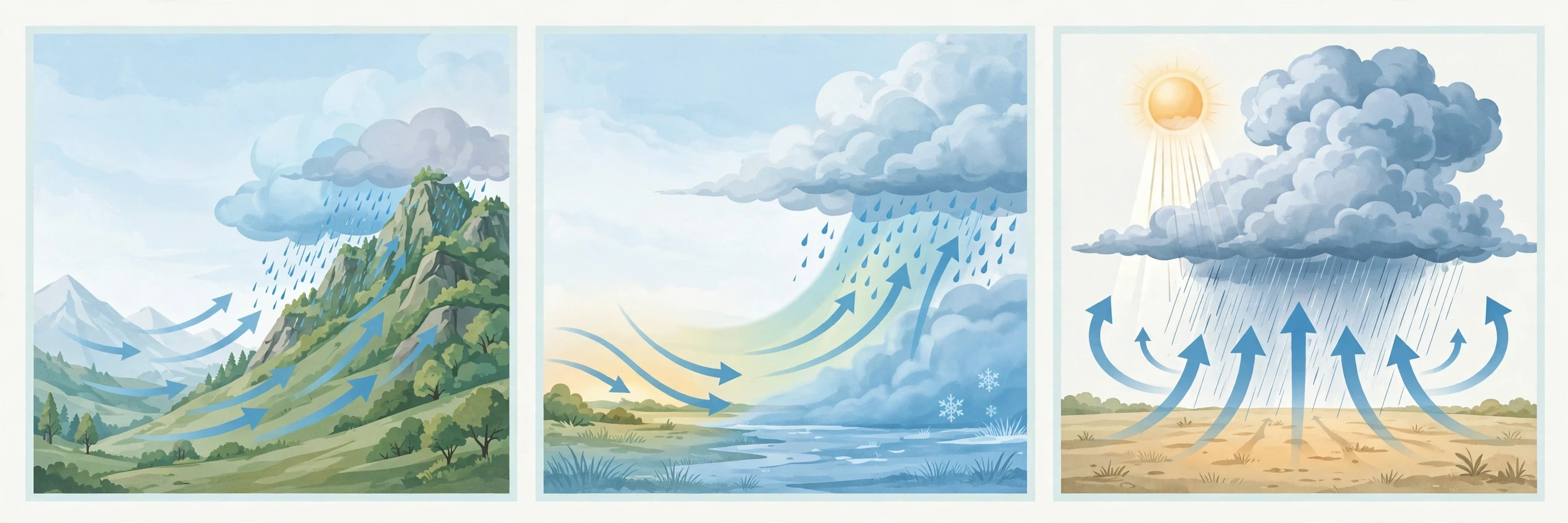
Rain needs rising air, and rising air needs a reason. In practice there are four main reasons, and between them they explain almost every rainy day you have ever had. Meteorologists call them lifting mechanisms, and they are the reason weather forecasts talk about fronts, mountains, and afternoon thunderstorms as different kinds of rain. They are different — not in the physics of the droplets, but in what pushes the air up in the first place.
4.1 Convection: the Sun heats the ground, the ground heats the air
On a warm day, the Sun heats the ground unevenly — a dark ploughed field warms faster than a lake, a city street faster than a park. The air above the warm patches heats up, becomes less dense than the air around it, and rises in a bubble, the way a hot-air balloon rises. This is convection, and it is the engine of the classic summer afternoon thunderstorm. The rising bubble cools, condenses, and builds a towering cumulus cloud. If the air is moist enough and the updraft strong enough, the cloud grows into a cumulonimbus — a thunderhead that can reach the top of the troposphere, ten kilometres or more — and drops heavy, short-lived rain, often with lightning and hail.
Convective rain is local and intense. It can pour on one street and leave the next one dry, which is why summer storms feel so unfair. I have stood on a porch and watched rain hammer the field across the road while the roof above me stayed dry. The storm was a column of rising air a few kilometres wide, and I was simply outside it. Convective rain also explains why the tropics get their rain in the afternoon: the Sun does its heating work all morning, the air gets unstable, and by mid-afternoon the clouds boil up and break. The Met Office's guide to rain describes convective rainfall as the type that produces the heavy, showery downpours of summer, and anyone who has been caught in one will recognise the description.
4.2 Orographic lift: mountains squeeze the sky
When wind meets a mountain, it has nowhere to go but up. The air is forced to climb the slope, cooling as it rises, condensing, and dropping its water on the windward side — the side facing the wind. By the time the air crosses the summit and descends on the far side, it has lost most of its moisture. Descending air warms and dries, so the leeward side sits in a rain shadow: dry, often desert-dry, while the other side of the same mountain is green and wet.
This is one of the most reliable rain-making machines on Earth, and it is why mountain ranges draw such sharp lines on rainfall maps. The western slopes of the mountains in the Pacific Northwest of North America, the southern slopes of the Himalayas, the windward side of Hawaii's mountains — all of them are wet because the wind has to climb. And the land just behind them is dry for the same reason. The difference can be dramatic: a few dozen kilometres can separate a rainforest from a desert. I once drove across a mountain pass on a wet, grey morning, through dripping forest and low cloud, and came out the other side into bright sunshine and dry grassland, as if someone had drawn a line across the landscape with a ruler. That line was the rain shadow, and it was as real as any border on a map.
4.3 Frontal lift: warm air slides up over cold air
The third mechanism is the one behind most of the steady, all-day rain in temperate regions. Air masses — huge bodies of air with a roughly uniform temperature and humidity — drift around the planet, and where a warm air mass meets a cold one, they do not mix politely. The warm air, being less dense, slides up and over the cold air, like a wedge. As it rises along that sloping boundary, called a front, it cools and condenses, producing broad sheets of cloud and long, steady rain. A warm front can bring a day or more of gentle, persistent rain. A cold front, where cold air pushes under warm air and shoves it up more violently, brings shorter, heavier bursts, often with thunderstorms.
Frontal rain is the rain of the mid-latitudes: the grey November drizzle in London, the steady rain that soaks a whole region for a weekend, the kind of rain that makes you cancel a picnic rather than run for cover. It is less dramatic than a thunderstorm, but it delivers far more water over a wider area, and it is the rain that fills reservoirs and waters crops across much of Europe, North America, and East Asia. If you want to understand the weather where you live, learn your fronts. The NOAA JetStream pages explain how frontal systems organise rainfall over thousands of kilometres, and why a single front can water a whole country.
4.4 Convergence: winds meet and pile up
The fourth mechanism is the simplest to picture. When winds blow toward each other and meet, the air has nowhere to go but up — the same way water piles up where two streams join. This happens on a grand scale near the equator, where the trade winds from the northern and southern hemispheres meet in a band called the Intertropical Convergence Zone. Air piles up, rises, and produces the towering thunderstorms and heavy rain of the equatorial belt — the reason rainforests grow where they do. It also happens on smaller scales, along coastlines where a sea breeze meets the land breeze, and around cities, where the urban heat island can trigger its own small storms. Convergence is the quiet partner of the other three mechanisms, and it often works together with them: a front, a mountain, and converging winds can all lift the same air at once.
5. The Many Faces of Rain
Not all rain is the same, and the differences matter. A farmer, a pilot, a city engineer, and a person deciding whether to carry an umbrella all care about different things: how hard it falls, how long it lasts, how big the drops are, and whether it will freeze when it lands. Meteorologists sort rain into types, and the table below gives the ones you are most likely to meet.
Type | Drop size | How it feels | Typical cause |
|---|---|---|---|
Drizzle | Less than 0.5 mm | A fine mist that wets slowly; umbrellas barely help | Low stratus cloud, gentle lift |
Light rain | 0.5–1 mm | Steady, gentle; you can walk in it | Frontal or stratiform cloud |
Moderate rain | 1–2 mm | Soaks through in minutes; puddles form | Frontal systems, thicker cloud |
Heavy rain / showers | 2–5 mm | Hard, noisy, poor visibility | Convection, thunderstorms |
Freezing rain | 1–3 mm | Rain that freezes on contact; ice coats everything | Warm rain falling through sub-freezing air near the ground |
Virga | Any size | Rain you can see but never feel — it evaporates before landing | Rain falling through dry air below the cloud |
5.1 Drizzle: rain that never grew up
Drizzle is the smallest, gentlest form of rain. Its drops are under half a millimetre across, so small that they fall slowly and drift sideways in the wind. Drizzle comes from low, flat stratus clouds, the grey sheets that cover the sky on a dull day, and it can last for hours without ever amounting to much water. It is the rain that makes you damp rather than wet, and it is easy to underestimate: a whole day of drizzle can still add up to several millimetres of water, enough to matter for a garden or a reservoir. The difference between drizzle and light rain is just drop size, and the difference between drizzle and fog is just height: fog is a cloud at ground level, and drizzle is what happens when the droplets in a low cloud get just heavy enough to fall — barely.
5.2 Showers: short, sharp, and local
Showers are convective rain: short bursts from individual cumulus clouds, often with sunshine between them. The classic shower is the April shower of nursery rhymes — sun, then rain, then sun again — and it happens because each shower comes from one cloud passing overhead, not from a broad weather system. Showers can be surprisingly heavy while they last, dropping several millimetres in ten minutes, and then they stop as suddenly as they started. The saying "April showers bring May flowers" is, for once, exactly right: the short, intense watering is good for plants, and the sunshine between showers lets the soil breathe.
5.3 Freezing rain: the most dangerous kind
Freezing rain is ordinary rain that becomes dangerous on arrival. It happens when snow falls from a cloud, melts as it passes through a warm layer of air, and then falls through a shallow layer of sub-freezing air near the ground. The drops become supercooled — liquid below zero degrees — and the moment they touch a cold surface, they freeze instantly, coating roads, trees, and power lines in clear ice. A few millimetres of ice can bring down branches and power lines, turn roads into skating rinks, and close a city. Freezing rain is rare compared with ordinary rain, but it causes more damage per millimetre than any other kind, and it is the reason forecasters treat a winter storm with a warm layer aloft as a serious threat.
5.4 Virga: rain that never arrives
Virga is rain that falls from a cloud and evaporates before it reaches the ground. You can see it as grey streaks hanging beneath a cloud base, like jellyfish tentacles, in dry air. In deserts, much of the rain that clouds produce never lands — it evaporates on the way down, cooling the air below, which can trigger gusty winds at the surface. Virga is a reminder that rain is not guaranteed by a cloud. The air below the cloud has to be moist enough for the drops to survive the fall, and in dry places it often is not. From the ground, virga looks like a promise the sky did not keep.
6. Why Raindrops Are Not Teardrop-Shaped
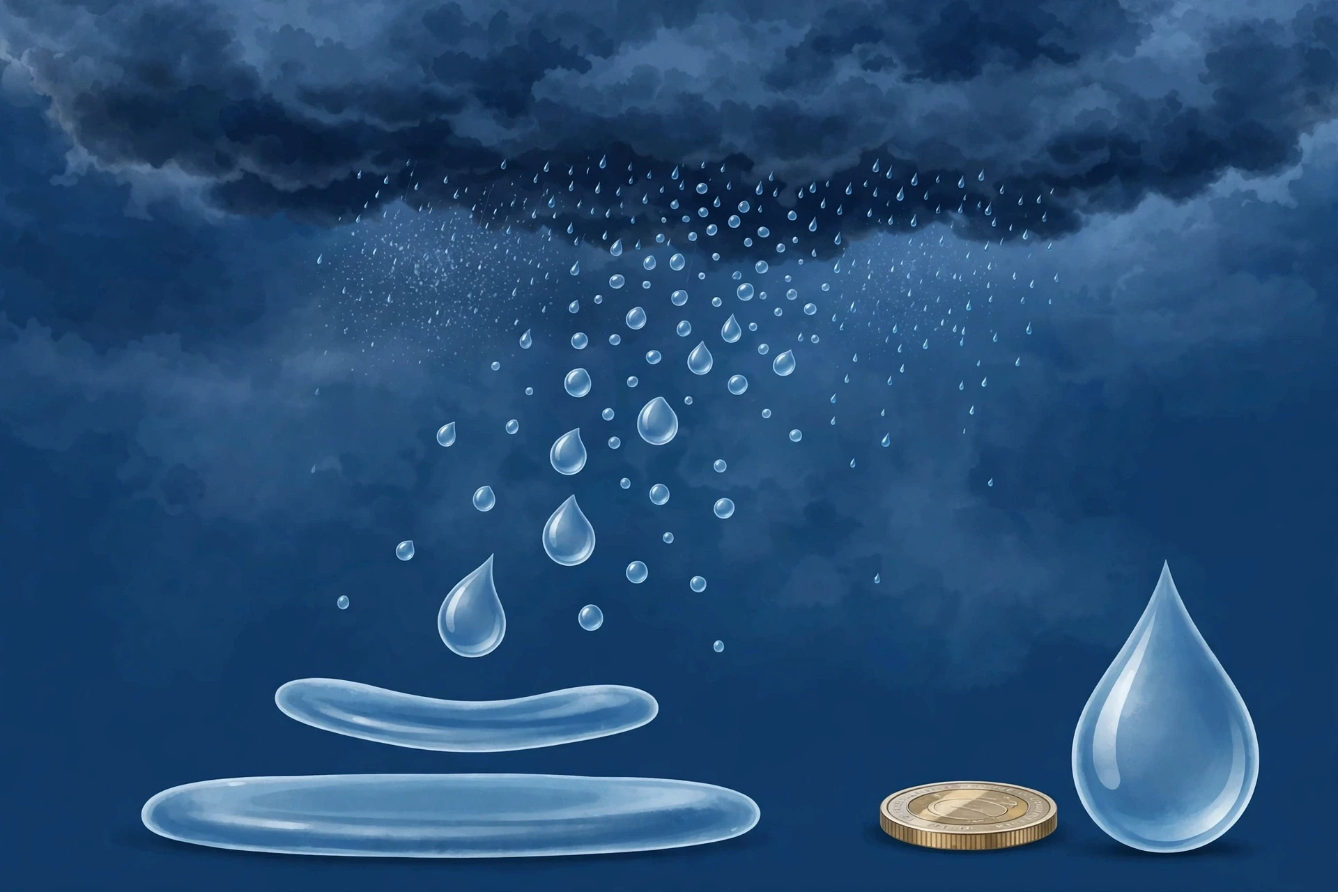
Ask a child to draw a raindrop and you will get a teardrop: round at the bottom, pointed at the top. It is one of the most persistent images in the world, and it is wrong. Real raindrops are not teardrop-shaped at all. Small raindrops are nearly perfect spheres. As they grow larger, air resistance flattens their bottoms, and they become shaped like a hamburger bun — flat underneath, rounded on top. Very large drops, above about 4 or 5 millimetres, become unstable and break apart into smaller drops. That is why raindrops have a maximum size: beyond it, they cannot hold together.
The reason is physics, and it is the same physics that shapes a parachute. A falling drop pushes air out of the way, and the air pushes back. At the bottom of the drop, the air pressure is highest, so the bottom flattens. At the top, the air flows smoothly over the curve. The surface tension of water tries to hold the drop in a sphere — one of the strange consequences of water's hydrogen bonds, explored in Why Water Is the Weirdest Molecule — and the air pressure tries to flatten it, and the shape you get is the compromise between the two. The faster the drop falls, the flatter it gets. High-speed photographs of falling rain show this clearly: a crowd of small spheres and flattened buns, no teardrops anywhere.
This matters for more than trivia. The shape and size of raindrops determine how fast they fall, and how fast they fall determines how much rain reaches the ground before the cloud moves on. A small drizzle drop falls at about 2 kilometres per hour — slow enough to drift sideways in a breeze and evaporate on the way down. A large raindrop falls at about 30 kilometres per hour. That difference is why heavy rain feels the way it does: the drops are bigger, faster, and harder, and they arrive in a rush rather than a drift. Weather radar, which we will meet in the next section, reads rain partly by the size and shape of the drops, because large drops reflect radar signals differently from small ones.
6.1 How fast does rain fall?
Terminal velocity — the steady speed a falling object reaches when air resistance balances gravity — is the speed of rain. For a drizzle drop it is barely a walking pace. For a large raindrop it is roughly the speed of a cyclist going downhill. And because the speed depends on size, rain does not fall as a uniform sheet. It falls as a mixed crowd, small drops drifting, large drops plunging, all of them accelerating until the air holds them back. If there were no air, a raindrop falling from a cloud two kilometres up would hit the ground at highway speeds. Air resistance is the reason rain is gentle enough to stand in — and the reason a hailstone, which is solid ice and falls faster, is not.
7. How Scientists Measure Rain
You cannot manage what you do not measure, and rain is measured more carefully than most people realise. Farmers need it, water companies need it, flood forecasters need it, and climate scientists need it — and each of them needs a different kind of measurement. The result is a layered system, from a simple bucket in a garden to satellites that weigh the rain falling on the open ocean.
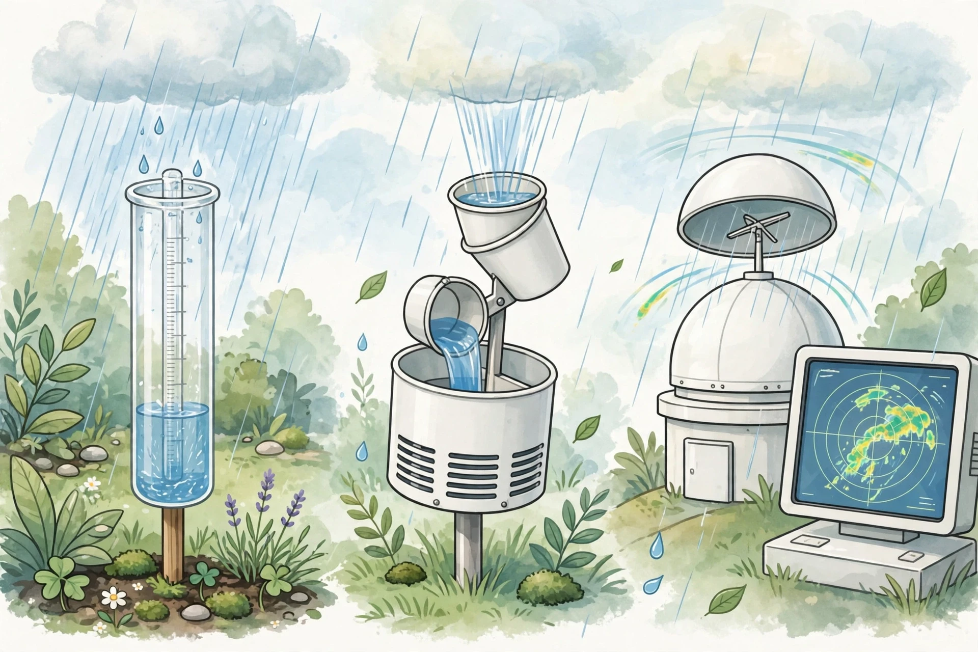
The oldest tool is the rain gauge, and it has barely changed in centuries: a cylinder, open at the top, that catches rain and measures how deep the water is. Rainfall is reported as a depth — millimetres or inches — because that is the most useful number. Ten millimetres of rain means a layer of water ten millimetres deep over every square metre of ground, whether the ground is a garden or a city. One millimetre of rain over one square metre is one litre of water. One inch of rain over one acre is more than 27,000 gallons. Depth makes the numbers comparable across places and times, and it makes the scale of rain vivid: a storm that drops 100 millimetres has put 100 litres of water on every square metre it passed over.
7.1 Gauges: simple, accurate, and local
A standard rain gauge is accurate but it only measures one point. A modern tipping-bucket gauge improves on it by recording when the rain falls: a small bucket tips over each time it fills with a fixed amount of water, and each tip is logged, so the record shows not just how much rain fell but when it fell and how hard. Networks of these gauges, run by weather services around the world, form the backbone of rainfall records. Their weakness is coverage. Most of the planet has no gauge — the oceans, the deserts, the mountains, the forests — and rain can vary sharply over short distances, so a gauge a few kilometres away can miss a storm entirely.
I learned this the hard way as a teenager, when I kept a rain gauge in our garden for a school project. I recorded every morning for a month, proud of my neat table of numbers, and then discovered that a friend two streets away, who had been doing the same thing, had recorded a completely different month. We had both measured correctly. It had simply rained differently on our two streets. Convective showers are that local. My little project taught me something no textbook had: a single rain gauge tells you the truth about one place, and only one place.
7.2 Radar: seeing rain across a region
Weather radar fills the gap between gauges. A radar station sends out pulses of radio waves, and raindrops scatter some of that energy back. The stronger the return signal, the heavier the rain. Modern Doppler radar also measures the motion of the drops, which reveals wind patterns inside storms and helps forecasters spot rotation that can produce tornadoes. Radar gives a live map of rain over hundreds of kilometres, updated every few minutes, and it is the reason your weather app can show you a rain map and tell you, with reasonable confidence, whether it will rain in the next hour.
Radar has limits. It measures the rain high in the sky, not at the ground, and the drops can evaporate on the way down — the virga problem again. It struggles in mountains, where the beam can be blocked, and it cannot tell you exactly how much water will land. So forecasters calibrate radar with gauges, combining the two: gauges for accuracy, radar for coverage. It is a good example of how science works in practice — no single instrument is enough, and the answer comes from combining them.
7.3 Satellites: weighing rain where no one lives
For the two-thirds of the planet covered by ocean, and for the remote land where gauges are sparse, satellites do the job. Missions like NASA's Global Precipitation Measurement (GPM) mission carry radar and microwave sensors that estimate rainfall from space, covering the whole planet every few hours. This matters enormously, because most rain falls on the ocean, where no one measures it directly, and because tropical rainfall drives the global climate. Satellite data has transformed our understanding of where rain falls and how much of it there is, and it is the main reason we can now talk with confidence about global rainfall patterns. NASA's GPM pages explain how the mission measures rain and snow from orbit, and why that measurement matters for flood forecasting and farming in places with no ground stations.
7.4 How much rain is a lot?
Rainfall intensity is classified so that forecasters, engineers, and the public can talk about it in the same language. The table below gives the standard bands used by weather services, in millimetres per hour.
Intensity | Rate (mm per hour) | What it looks and feels like |
|---|---|---|
Light | Less than 2.5 | Gentle; you can stay out without an umbrella for a while |
Moderate | 2.5–7.5 | Steady rain; umbrellas needed; puddles form |
Heavy | 7.5–50 | Hard rain; poor visibility; roads start to flood |
Violent | More than 50 | Torrential; dangerous flash flooding; usually tropical downpours or thunderstorms |
A useful sense of scale: a city drainage system is usually designed to cope with moderate to heavy rain, but not with violent rain. When a storm drops 50 millimetres in an hour — a rate seen in tropical downpours and severe thunderstorms — the water arrives faster than drains, soil, and rivers can move it away, and that is when flooding starts. The number matters more than the drama: flooding is, in the end, an accounting problem, water in versus water out.
8. Why Some Places Drown While Others Stay Dry
Rain is not spread evenly over the planet, and the pattern is not random. It follows the shape of the atmosphere's circulation, the position of the oceans and mountains, and the seasons. Once you know the pattern, a world rainfall map starts to read like a story.
8.1 The wet equator and the dry subtropics
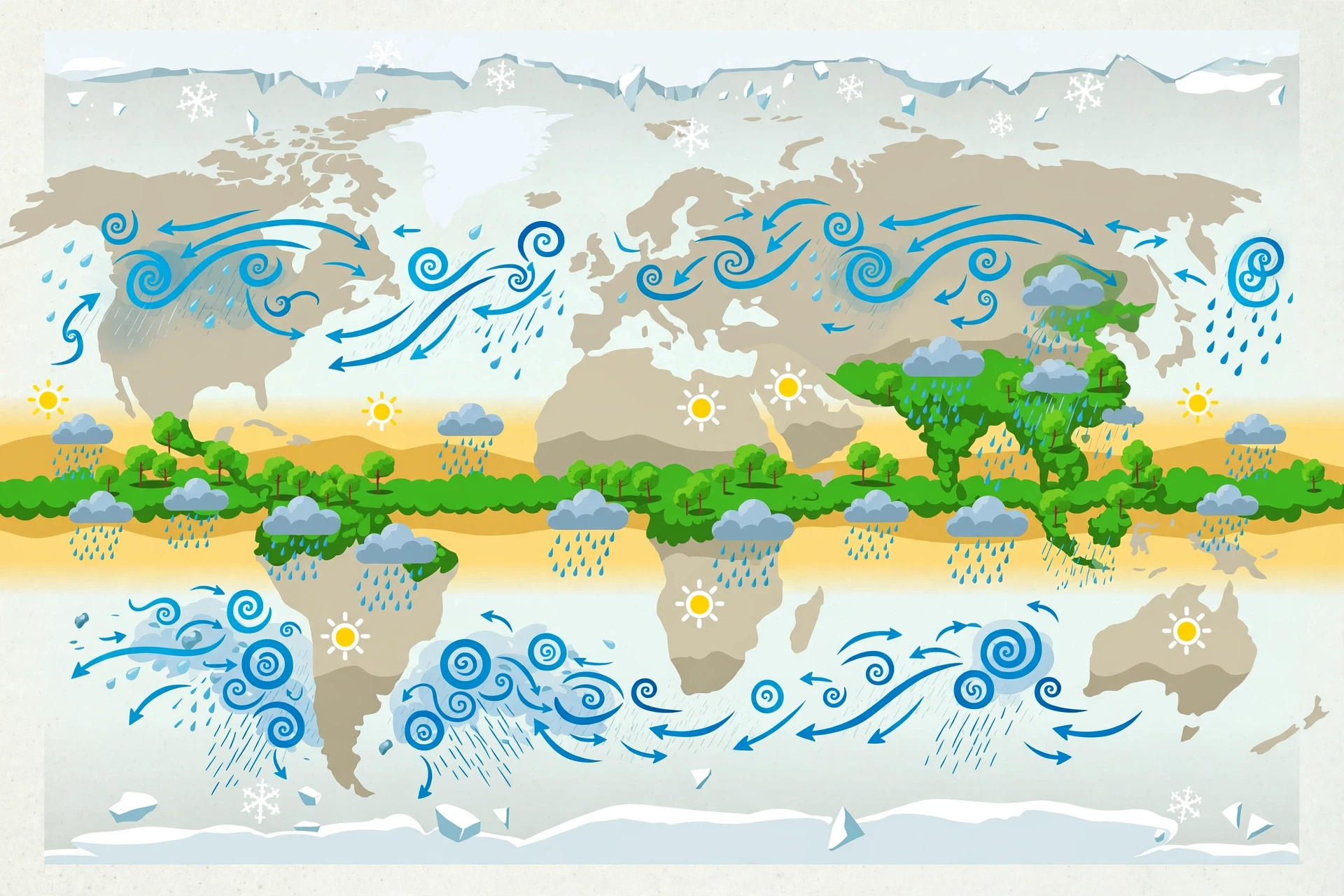
The wettest places on Earth sit near the equator, and the driest sit about 25 to 30 degrees north and south of it. The reason is the planet's great circulation cells. At the equator, warm air rises — the convergence zone we met in section 4 — and rising air makes rain. That rising air then flows away at high altitude and sinks back down in the subtropics, and sinking air warms, dries, and suppresses rain. So the equator gets rainforests, and the subtropics get the Sahara, the Arabian Desert, the Australian Outback, and the Atacama. The pattern is so regular that you can predict a place's rainfall, roughly, from its latitude alone.
The wettest inhabited places on Earth, in the hills of north-eastern India, receive more than 11 metres of rain in a year — as much rain in twelve months as some deserts receive in centuries. The driest, in the Atacama Desert of Chile, have weather stations that have never recorded rain at all. Both extremes are produced by the same circulation, and both are stable: the Atacama has been dry for millions of years, because the sinking air above it and the cold ocean current beside it have been there for millions of years.
8.2 Monsoons: the seasons turn the wind around
In South Asia, East Asia, and parts of Africa and Australia, rain follows the seasons in a dramatic swing called the monsoon. In summer, the land heats up faster than the ocean, moist air rushes in from the sea, and the result is months of heavy rain. In winter, the pattern reverses: the land cools, dry air flows out to sea, and the rain stops. The summer monsoon delivers most of the year's rain in a few months, and billions of people depend on it for their crops. A monsoon that arrives late, or weak, or too strong, is not a weather story — it is a food story, and a flood story, and an economic story all at once.
The word monsoon comes from an Arabic word for season, and the season is the point. Monsoon rain is not a storm. It is a climate — a months-long pattern that whole civilisations have built their farming calendars around. When I was caught in that downpour as a twelve-year-old, I was standing in the middle of the monsoon, and the rain that soaked me was part of a system big enough to water a subcontinent.
8.3 The mid-latitudes: storm tracks and seasons
Between the subtropics and the poles, rain comes mainly from the travelling storms of the mid-latitudes — the low-pressure systems that march across the Atlantic and Pacific, bringing frontal rain to Europe, North America, and East Asia. These storm tracks shift with the seasons: in winter they move toward the equator, bringing rain to places like California and the Mediterranean, and in summer they retreat poleward. That seasonal shift is why the Mediterranean has wet winters and dry summers, and why California's rain arrives almost entirely between November and March.
Mountains sharpen all of this. A coastal mountain range facing the prevailing wind can multiply rainfall several times over, while the land behind it stays dry. The rain shadow is one of the most visible effects in geography: you can drive from a rainforest to a desert in an afternoon, as I did on that mountain pass, and the only thing that changed was which side of a ridge you were standing on.
8.4 Why rain is so hard to forecast precisely
Forecasters can predict rain a few days ahead with good skill, and they can predict whether it will rain in the next hour with even better skill, but predicting exactly how much rain will fall on one particular street, at one particular time, remains hard. The reason is scale. Rain is made by processes that happen at the scale of a cloud droplet, a rising bubble of air, a single mountain slope — and those small processes add up into weather systems thousands of kilometres wide. A forecast model has to simulate all of that, and small errors at the small scale grow into big errors at the large scale. This is not a failure of forecasting. It is a property of the atmosphere. The meteorology guide explains how forecasters combine models, radar, and satellite data to narrow the uncertainty — and why a forecast that says "a 60 percent chance of rain" is being honest, not evasive.
9. What Rain Does to the Land
Rain does far more than make things wet. It is the main sculptor of the land surface, the main water supply for almost every ecosystem on Earth, and the main source of fresh water for people. It is also, when there is too much of it, one of the most destructive forces in nature.
9.1 Rain feeds the world
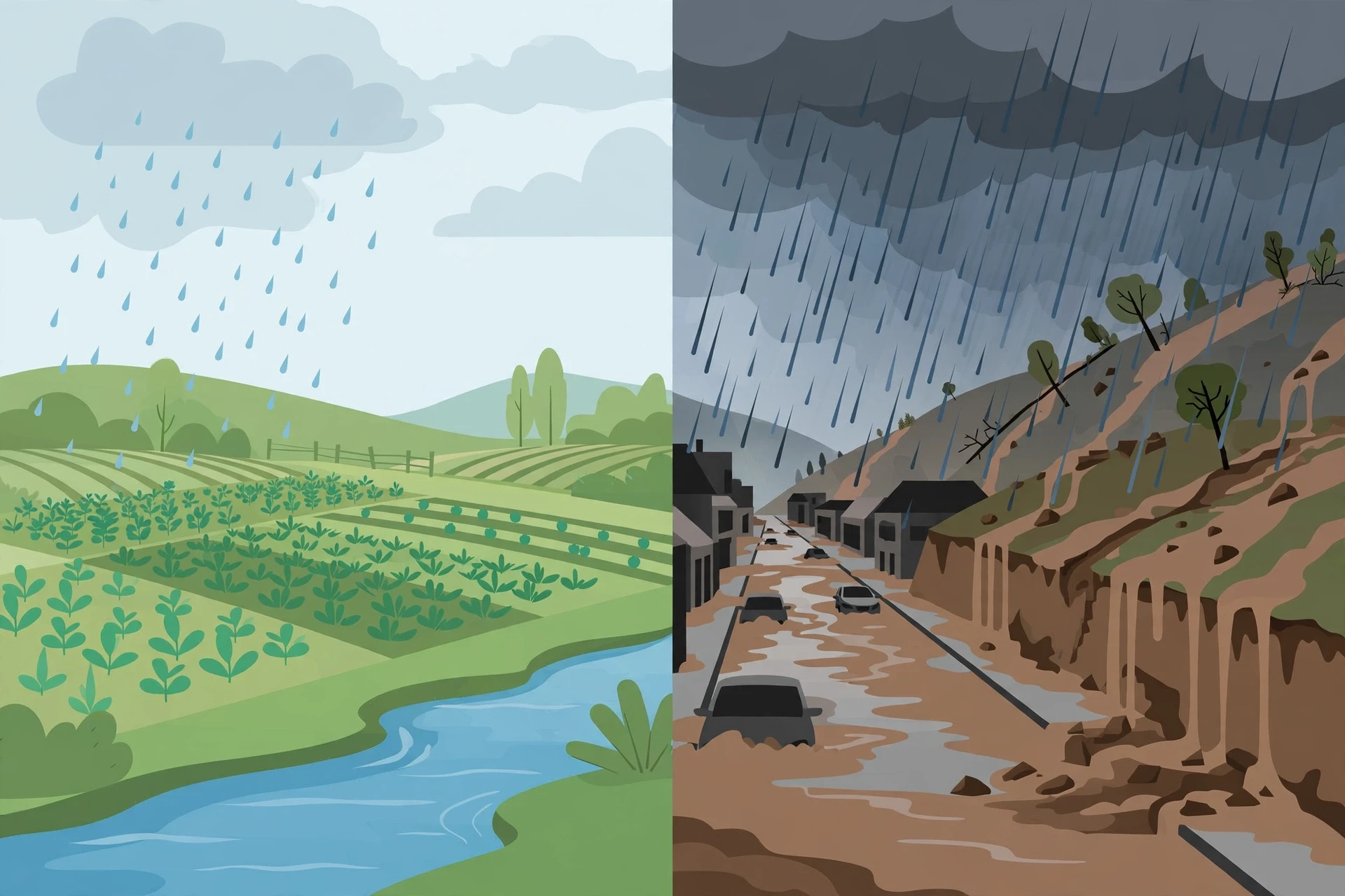
Nearly all farming depends on rain, directly or indirectly. Rain-fed agriculture — crops grown without irrigation — produces most of the world's food, and it depends entirely on rain arriving in the right amount at the right time. Too little, and crops fail. Too much, and they drown. The timing matters as much as the total: rain that falls before planting is useless, rain that falls after harvest is a nuisance, and rain that falls during flowering can decide whether a harvest is good or bad. This is why farmers watch the sky with more attention than almost anyone else, and why a change in rainfall patterns is a change in food security.
Rain also recharges groundwater, the water stored in soil and rock beneath the surface. When rain soaks into the ground, some of it is held in the soil for plants, and some seeps deeper, into aquifers that supply wells and springs. In many parts of the world, groundwater is the main source of drinking water, and it is replenished only by rain. A drought is not just a dry spell on the surface. It is a failure to refill the underground reservoir, and it can take years of normal rain to recover.
9.2 Rain sculpts the landscape
Given enough time, rain reshapes the Earth. Each drop hits the ground with a small impact, and millions of drops dislodge soil particles, which runoff carries away. On a slope, that becomes erosion: gullies, rills, and eventually valleys. Rivers, fed by rain, carve canyons over millions of years. The Grand Canyon is, in the end, a rain story — water falling on a high plateau, gathering into streams, and cutting down through rock, a millimetre at a time, for millions of years.
Rain also dissolves rock. Rainwater is slightly acidic — it picks up carbon dioxide from the air and forms a weak carbonic acid — and over time it dissolves limestone, carving caves and sinkholes and the strange tower landscapes of places like southern China. The chemistry is slow and the results are spectacular. The same weak acidity is why rainwater tastes different from tap water, and why it is so good for plants: it carries dissolved carbon dioxide and, as it falls through the air, it picks up nitrogen compounds that act as a mild fertiliser. Gardeners have always known that plants grow better after rain than after watering, and the chemistry backs them up.
9.3 When rain becomes a flood
Too much rain, too fast, is one of the most common natural disasters on Earth. A flash flood can turn a dry riverbed into a raging torrent in minutes, and river floods can displace millions of people. The damage is not just from the water itself. Flood water carries mud, debris, and sewage, it undermines roads and buildings, and it leaves behind stagnant water where disease can spread. The deadliest floods in history have killed hundreds of thousands of people, and flooding remains the most frequent weather-related disaster in the world.
Floods are getting more attention from city planners because cities make flooding worse. Concrete and asphalt do not absorb rain the way soil does, so rain that would have soaked into a field runs straight off a city street and into drains that were not designed for it. A city can flood from a storm that would have been harmless in the countryside. The solutions — permeable pavements, green roofs, parks designed to hold water, restored wetlands — are all ways of giving rain somewhere to go, instead of forcing it through pipes that cannot cope. In a sense, the best flood defence is to let the land do what it used to do: soak rain up slowly.
10. Rain, Climate, and a Changing World
Rain is changing. As the planet warms, the physics of rain changes with it, and the changes are already visible in rainfall records around the world. The basic rule is simple and comes straight from the physics we have already met: warmer air can hold more water vapour. Roughly speaking, the air can hold about 7 percent more vapour for every degree Celsius of warming. That means more water is available to fall as rain — but it does not mean rain increases everywhere, or that it falls gently.
What the records show is a pattern of intensification. When it rains, it tends to rain harder. Short, heavy downpours are becoming more common in many regions, because a warmer atmosphere loads up with more vapour and then unloads it in bigger bursts. At the same time, dry spells between rains are getting longer in some places, because the same extra heat dries the soil faster. The result is a world of sharper contrasts: wetter wet spells and drier dry spells, with less of the steady, moderate rain in between. For farmers, that is the worst combination — too much water at once, then not enough for weeks.
The geography of rain is shifting too. The dry subtropics are expected to expand poleward as the circulation changes, making some already-dry regions drier. Monsoon patterns are shifting, with more intense bursts and more variable timing. And the rain that falls as snow in mountains is increasingly falling as rain instead, which changes when the water arrives downstream: snow is a reservoir that releases water slowly through spring and summer, while rain runs off at once, so a shift from snow to rain can mean floods in winter and shortages in summer. Water managers in mountain regions are already planning for this.
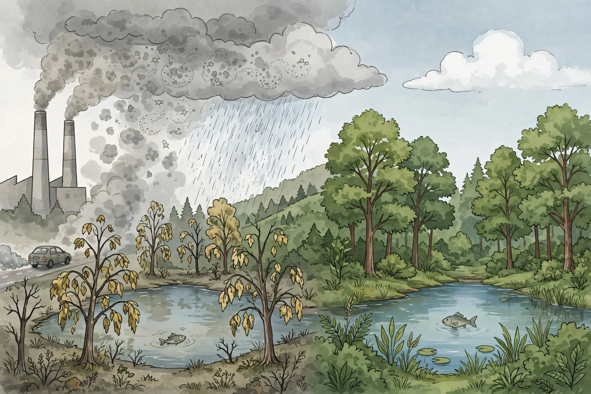
10.1 Acid rain: when the sky carries pollution
Rain does not fall through clean air. As drops fall, they absorb gases, and when the air carries sulphur dioxide and nitrogen oxides from burning coal, oil, and gas, the rain becomes more acidic than it should be. Normal rain is already slightly acidic, with a pH of about 5.6, because of the carbon dioxide in the air. Acid rain can have a pH below 5, and in badly polluted regions it has been measured far lower. That extra acidity damages forests, stripping nutrients from soil and weakening trees; it acidifies lakes, killing fish and the insects they feed on; and it eats away at stone buildings and statues, dissolving the limestone that holds them together.
The good news is that acid rain is a solvable problem. Regulations that cut sulphur dioxide emissions in North America and Europe in the late twentieth century reduced acid rain sharply, and forests and lakes in many regions have started to recover. It is one of the clearest examples of an environmental problem that was identified, measured, and fixed by policy — and a reminder that the sky is not separate from what we put into it. The water in the rain has passed through the air we all share.
Rain is the planet's way of moving water from where it is to where it is needed. When we change the air, we change the rain — and when we change the rain, we change everything that depends on it.
11. Common Misconceptions About Rain
Rain is so familiar that people carry a surprising number of wrong ideas about it. Here are the ones I meet most often, and what the evidence actually says.
11.1 "Clouds are made of water vapour"
Most people assume a cloud is a bag of invisible water vapour. What we actually see in the data — and in the sky — is different: a cloud is a crowd of liquid droplets or ice crystals. Water vapour is invisible, and it is the raw material, not the product. The cloud is what you get after the vapour condenses. This is not a pedantic distinction. If clouds were vapour, they would not scatter sunlight the way they do, they would not be white, and they would not rain. They rain precisely because they are made of liquid, and liquid can grow heavy enough to fall.
11.2 "Raindrops are teardrop-shaped"
As section 6 showed, real raindrops are spheres when small and flattened buns when large. The teardrop shape comes from drawings, not from the sky. A drop falling through air has no tail — the air smooths it out. The image is so familiar that weather graphics still use it, and that is fine for a symbol, but it is not what rain looks like.
11.3 "It rains because clouds get too heavy"
Clouds do not get heavy and then collapse. A cloud is mostly air, and the droplets inside it are so small that they float. Rain happens when individual droplets grow large enough to fall on their own — not when the whole cloud tips over. A cloud can hold an enormous amount of water and never rain, if the droplets never grow. And a cloud that is raining is still floating: the updraft inside it is still rising, carrying new droplets up even as the grown ones fall out of the bottom.
11.4 "Rain cleans the air completely"
Rain does wash pollutants out of the air — it is one reason the air smells fresh after a storm — but it does not clean it completely, and what it washes out goes somewhere. The pollutants end up in the soil and the rivers, and in the case of acid rain, the rain itself becomes part of the pollution problem. Rain is a transfer, not a disappearance.
11.5 "Deserts never get rain"
Most deserts get some rain, just very little of it, and very irregularly. The Atacama is the famous exception, with some places that have gone years without measurable rain, but most deserts receive a few centimetres a year, often in rare, violent storms. The problem with deserts is not that rain never falls. It is that it falls rarely, unpredictably, and evaporates almost as fast as it lands, so almost none of it is available to plants. And when rain does fall on dry, baked ground, it often runs off in flash floods rather than soaking in.
11.6 "You can smell rain coming"
This one is partly true, and the truth is lovely. The smell of rain has a name — petrichor — and it comes from oils released by plants and from a compound called geosmin, made by soil bacteria, which is released when rain hits dry earth. Human noses are extraordinarily sensitive to geosmin: we can detect it at a few parts per trillion. So yes, you can smell rain, and the reason you can is that your ancestors needed to know where water was. The part that is a myth is that the smell predicts rain. You smell it after the first drops land, not before.
Frequently Asked Questions
How does rain form?
Rain forms when water vapour in rising air cools and condenses onto tiny dust and salt particles, creating cloud droplets. Those droplets then grow — by colliding and merging in warm clouds, or by ice crystals growing at the expense of supercooled droplets in cold clouds — until they are about a millimetre across and heavy enough to fall. Roughly a million cloud droplets go into a single raindrop.
Why does it rain more in some places than others?
Rainfall depends on how often air rises, how moist that air is, and what the land does to it. The equator is wet because air converges and rises there. The subtropics are dry because air sinks there. Mountains force moist wind upward and wring rain out of it, leaving dry rain shadows behind them. Oceans supply the moisture, so coastal areas downwind of warm seas usually get more rain than continental interiors.
Why do clouds sometimes not rain?
A cloud rains only when its droplets grow large enough to fall, which needs a thick, wet, long-lived cloud with a steady updraft. Most clouds fail at least one of those tests: they are too thin, too short-lived, or their droplets never get the chance to merge and grow. The droplets then simply evaporate as the cloud breaks up, and the water returns to the air as vapour.
What is the difference between rain, drizzle, and showers?
The difference is drop size and source. Drizzle has drops under half a millimetre from low, flat stratus clouds. Rain is the general term for drops over half a millimetre, usually from broad frontal or layered clouds. Showers are short, heavy bursts from individual convective cumulus clouds, often with sunshine between them. All three are liquid precipitation made by the same droplet-growth processes.
Can it rain when the sky is clear?
Almost never where you are standing, but rain can fall from a cloud that is not above you — wind can carry drops sideways, and a distant shower can drift over. What looks like rain from a clear sky is usually either a shower on the edge of a cloud you cannot see, or virga evaporating before it lands. True rain needs a cloud overhead.
Why does rain smell the way it does?
The smell is called petrichor. It comes from plant oils that collect in soil and rock during dry spells, and from geosmin, a compound made by soil bacteria, both of which are released into the air when raindrops hit dry ground. Human noses are extremely sensitive to geosmin, which is why the smell is so noticeable after the first rain following a dry period.
Will climate change make it rain more or less?
Both, in different places and at different times. A warmer atmosphere holds more water vapour, so heavy downpours are becoming more intense in many regions, while dry spells between rains are getting longer in others. The overall pattern is sharper contrasts: wetter wet periods, drier dry periods, and shifts in where and when the rain falls. The total amount of rain on Earth is expected to rise slightly, but the distribution is what matters — and that is changing.